IMAGES TAKEN NEAR TO
Millbank Road, MUNLOCHY, IV8 8NL
Introduction
This page details the photographs taken nearby to Millbank Road, IV8 8NL by members of the Geograph project.
The Geograph project started in 2005 with the aim of publishing, organising and preserving representative images for every square kilometre of Great Britain, Ireland and the Isle of Man.

There are currently over 7.5m images from over14,400 individuals and you can help contribute to the project by visiting https://www.geograph.org.uk
Image Map (Loading...)


Getting Data...Please wait
Leaflet Map data © OpenStreetMap
Images are licensed for reuse under creativecommons.org/licenses/by-sa/2.0
Notes
- Clicking on the map will re-center to the selected point.
- The higher the marker number, the further away the image location is from the centre of the postcode.
Image Listing (50 Images Found)
Images are licensed for reuse under creativecommons.org/licenses/by-sa/2.0
Image
Details
Distance
1
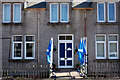
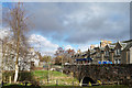
Home of a patriot, Munlochy
The house is next to the ScotMid village shop in Munlochy. The door is in the colours of the saltire and there are blue and white painted stones in front of the front door. Flags flying today are the saltire and the EU flag, and it has not been unusual to see the Basque flag too.
Image: © Julian Paren
Taken: 19 Apr 2020
0.00 miles
2
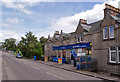
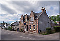
Shop in Millbank Road
Now a Scotmid Co-op, the shop was formerly Spar.
Image: © Richard Dorrell
Taken: 17 Jun 2014
0.01 miles
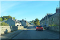
4
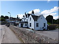
Allangrange Arms, Munlochy
Pub and restaurant.
Image: © David Bremner
Taken: 17 Apr 2023
0.01 miles
5
Shopping walk: ScotMid Munlochy and the Big Burn bridge
The destination of the walk. The ScotMid store for the week's essential shopping and the weekly newspaper. Sitting in the garden of the Allangrange Arms while my younger wife visits the shop.
Image: © Julian Paren
Taken: 28 Mar 2020
0.02 miles
6
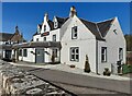
Royal Bank of Scotland, Munlochy
Located in Millbank Road. The bank appears to occupy one half of a former pair of semi-detached houses, though I couldn't guess which one of the pair the middle first floor window belongs to.
Image: © Richard Dorrell
Taken: 17 Jun 2014
0.02 miles
8
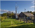
Weather Station at Munlochy
Situated next to the old Mill off Millbank Road
Image: © valenta
Taken: 15 Oct 2019
0.03 miles
9
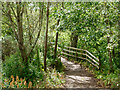
Highland Core Path RC 33.05 Burn Place to Primary School, Munlochy
This path close to the centre of Munlochy village allows school children who live to the north of the main road to access the school, without being on a pavement by the road. The image shows the bridge built to cross a burn that enters Munlochy Bay.
Image: © Julian Paren
Taken: 3 Jul 2024
0.03 miles
10
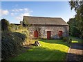
Munlochy Mill
Viewed from Millbank Road, the Mill does not have listed status and is undated, although it appears on the first 25" OS Map of 1880.
https://canmore.org.uk/site/112254/munlochy-mill
Image: © valenta
Taken: 15 Oct 2019
0.04 miles