IMAGES TAKEN NEAR TO
Totarder, Struan, ISLE OF SKYE, IV56 8FW
Introduction
This page details the photographs taken nearby to IV56 8FW by members of the Geograph project.
The Geograph project started in 2005 with the aim of publishing, organising and preserving representative images for every square kilometre of Great Britain, Ireland and the Isle of Man.

There are currently over 7.5m images from over14,400 individuals and you can help contribute to the project by visiting https://www.geograph.org.uk
Image Map
Images are licensed for reuse under creativecommons.org/licenses/by-sa/2.0
Notes
- Clicking on the map will re-center to the selected point.
- The higher the marker number, the further away the image location is from the centre of the postcode.
Image Listing (10 Images Found)
Images are licensed for reuse under creativecommons.org/licenses/by-sa/2.0
Image
Details
Distance
1
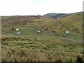
Grazing Land at Totardor
The river in front of the houses is the Amar River.
Image: © Dave Fergusson
Taken: 23 Mar 2008
0.05 miles
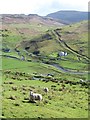
2

Totardor and Amer
Viewed here from the B885 road, this scattering of farmsteads and crofts lie at the head of the valley of the Amer River. Tracks from here lead off onto the moors where sheep wander freely, though there are fewer sheep kept here today than was the case in the past.
Image: © Richard Dorrell
Taken: 12 Jul 2012
0.07 miles
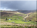
3
View across the glen
The view across towards the house at Fearan nan Cailleach and into Glen Bracadale beyond.
Image: © Gordon Hatton
Taken: 10 Apr 2014
0.10 miles
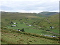
4
Fields in Glen Bracadale
Glen Bracadale as seen from the B885 connecting Portree with Struan.
Image: © Trevor Littlewood
Taken: 16 May 2015
0.13 miles
5
Bracadale: view over Totardor
A view into the steep-sided valley from the B885.
Image: © Chris Downer
Taken: 19 Aug 2012
0.13 miles
6
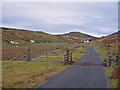
Road to Amar
The road is a 'dead end' in the township.
Image: © Richard Dorrell
Taken: 4 Nov 2008
0.14 miles
7
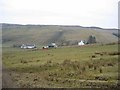
Amar Township
Looking NW to crofts at Amar.
Image: © John Allan
Taken: 24 Mar 2006
0.21 miles
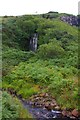
8
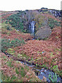
Waterfall in Allt na Cnodaich
When the burn is in a spate I believe water would also cascade over the rocks in the top right of the picture - I must pop back there after some heavy rain!
UPDATE - see http://www.geograph.org.uk/photo/1053722 !
Image: © Richard Dorrell
Taken: 4 Nov 2008
0.22 miles
9
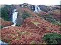
Waterfall in Allt na Cnodaich
I photographed this waterfall a couple of weeks ago (http://www.geograph.org.uk/photo/1033590 ) and thought at the time that after heavy rain there would be a further fall to the right.
Well, this is Skye, so it soon rained, and there was indeed a further waterfall to be seen.
Image: © Richard Dorrell
Taken: 10 Nov 2008
0.23 miles
10
Allt na Cnodaich
The burn is a tributary of the Amar River, which it joins not far below these falls. For a view of the falls in spate see Image
Image: © Tiger
Taken: 16 Aug 2013
0.23 miles