IMAGES TAKEN NEAR TO
Kyleakin, ISLE OF SKYE, IV41 8PL
Introduction
This page details the photographs taken nearby to IV41 8PL by members of the Geograph project.
The Geograph project started in 2005 with the aim of publishing, organising and preserving representative images for every square kilometre of Great Britain, Ireland and the Isle of Man.

There are currently over 7.5m images from over14,400 individuals and you can help contribute to the project by visiting https://www.geograph.org.uk
Image Map
Images are licensed for reuse under creativecommons.org/licenses/by-sa/2.0
Notes
- Clicking on the map will re-center to the selected point.
- The higher the marker number, the further away the image location is from the centre of the postcode.
Image Listing (127 Images Found)
Images are licensed for reuse under creativecommons.org/licenses/by-sa/2.0
Image
Details
Distance
1
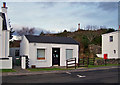
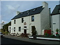
Former shop and post office
This tiny building served as the village shop and post office in Kyleakin, but closed in 2009. See also Image On the hill beyond is the Kyleakin war memorial.
Image: © Richard Dorrell
Taken: 19 Jan 2010
0.01 miles
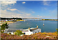
2
Kyleakin in 1999
The view from the exit to the car park towards the water's edge and across to houses at South Obbe.
Image: © Ruth Riddle
Taken: 20 Aug 1999
0.02 miles
3
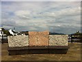
Public art in Kyleakin
On the harbour
Image: © Andrew Abbott
Taken: 19 May 2014
0.02 miles
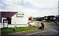
4

Restaurant and bar, Kyleakin
This modern facility is located adjacent to the village car park. It was rather quiet in January, but in summer, its presence must help Kyleakin to attract a few extra visitors.
Image: © Richard Dorrell
Taken: 19 Jan 2010
0.03 miles
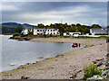
5
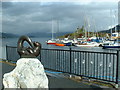
Caol Acain Harbour and Caisteal Maol
The name of the village, Kyle Akin is from the Scots Gaelic Caol Acain, meaning the “Strait of Haakon” named after the Norwegian King Haakon.
Image: © Nigel Homer
Taken: 27 May 2006
0.03 miles
6
Harry's Cafe
The Cafe sits on the main street overlooking An t-Ob.
Image: © Dave Fergusson
Taken: 13 Jul 2009
0.03 miles
7
Winkle Hall and Winkle Beach
Winkle Hall and Winkle Beach are a two holiday homes on the shore of Kyle Akin, seen here from the top of An Cnap.
In the distance is the Skye Bridge.
Image: © John Allan
Taken: 11 Aug 2012
0.04 miles
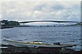
8
Kyleakin
Kyleakin (Scottish Gaelic: Caol Àcain) is a village situated on the east coast of the Isle of Skye in the Inner Hebrides. The village is along the strait of Kyle Akin opposite the northwest Scottish mainland town of Kyle of Lochalsh.
Image: © David Dixon
Taken: 23 Jun 2022
0.04 miles
9
Over the Bridge to Skye
This was taken in 1996 during my solo journey around Skye. The bridge was very new then.
Image: © Nick Ray
Taken: 8 Jun 1996
0.05 miles
10
Kyleakin harbour
Looking south west from the road to the ferry slipway.
Image: © Richard Dorrell
Taken: 19 Jan 2010
0.05 miles