IMAGES TAKEN NEAR TO
Glenurquhart Road, INVERNESS, IV3 8JL
Introduction
This page details the photographs taken nearby to Glenurquhart Road, IV3 8JL by members of the Geograph project.
The Geograph project started in 2005 with the aim of publishing, organising and preserving representative images for every square kilometre of Great Britain, Ireland and the Isle of Man.

There are currently over 7.5m images from over14,400 individuals and you can help contribute to the project by visiting https://www.geograph.org.uk
Image Map
Images are licensed for reuse under creativecommons.org/licenses/by-sa/2.0
Notes
- Clicking on the map will re-center to the selected point.
- The higher the marker number, the further away the image location is from the centre of the postcode.
Image Listing (199 Images Found)
Images are licensed for reuse under creativecommons.org/licenses/by-sa/2.0
Image
Details
Distance
1
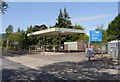
Derelict filling station, Torvean
This former petrol station is next to the A82 road, near Tomnahurich Bridge. It closed a number of years ago, and has since become derelict.
There have been several proposals for developing the site, with plans for blocks of flats here and on the adjacent caravan park. But it seems these plans have since been abandoned.
Image: © Craig Wallace
Taken: 26 Jun 2014
0.02 miles
2
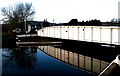
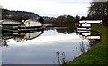
Tomnahurich swing bridge, Inverness
The bridge is open to allow a boat to pass along the Caledonian Canal. The bridge keeper's cottage beyond the bridge probably dates from about 1820 and is Category C listed [http://portal.historicenvironment.scot/designation/LB52230].
Image: © Richard Sutcliffe
Taken: Unknown
0.03 miles
3
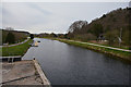
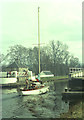
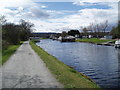
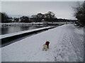
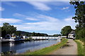
Inverness : Caledonian Canal
The Caledonian Canal connects the Scottish east coast at Inverness with the west coast at Corpach near Fort William in Scotland.
Image: © Lewis Clarke
Taken: 24 Apr 2016
0.03 miles
4
Tomnahurich Bridge
A close look at the bridge. It is hinged at the far end and swings counterclockwise to open.
Image: © Anne Burgess
Taken: 26 Dec 2008
0.03 miles
5
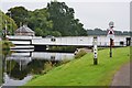
Tomnahurich swing bridge is open to canal traffic
The swing bridge carries vehicular traffic on the A82 over the Caledonian Canal.
Image: © Douglas Nelson
Taken: 25 Apr 2018
0.03 miles
6
Tomnahurich swing bridge, Inverness
The bridge over the Caledonian Canal for the A82 entering the city from the SW.
Image: © Jim Barton
Taken: 7 Sep 2016
0.04 miles
7
Inverness, Tomnahurich bridge
Inverness, Tomnahurich bridge, this swings to one side, to let boats up and down the Caledonian Canal
Image: © Colin Prosser
Taken: 13 Oct 2007
0.04 miles
8
Tomnahurich Bridge
The bridge has been opened to allow the passage of MV 'Lord of the Glens' on her way north to Muirton Basin.
Image: © Anne Burgess
Taken: 26 Dec 2008
0.04 miles
9
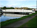
Towards Tomnahurich Swing Bridge on Caledonian Canal
Image: © Douglas Nelson
Taken: 13 Jan 2021
0.04 miles
10
Tomnahurich Bridge, Inverness
One of two swing bridges which cross the Caledonian Canal in Inverness.
Image: © Mike Pennington
Taken: 13 Aug 2015
0.04 miles