IMAGES TAKEN NEAR TO
Gilbert Court, INVERNESS, IV3 8BT
Introduction
This page details the photographs taken nearby to Gilbert Court, IV3 8BT by members of the Geograph project.
The Geograph project started in 2005 with the aim of publishing, organising and preserving representative images for every square kilometre of Great Britain, Ireland and the Isle of Man.

There are currently over 7.5m images from over14,400 individuals and you can help contribute to the project by visiting https://www.geograph.org.uk
Image Map (Loading...)


Getting Data...Please wait
Leaflet Map data © OpenStreetMap
Images are licensed for reuse under creativecommons.org/licenses/by-sa/2.0
Notes
- Clicking on the map will re-center to the selected point.
- The higher the marker number, the further away the image location is from the centre of the postcode.
Image Listing (119 Images Found)
Images are licensed for reuse under creativecommons.org/licenses/by-sa/2.0
Image
Details
Distance
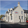
2
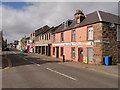
Suburban laundry, Grant Street, Inverness
Surprisingly, the rather scruffy ensemble is B-listed (LB35247 https://portal.historicenvironment.scot/designation/LB35247 ).
Image: © Bill Harrison
Taken: 12 Apr 2024
0.01 miles
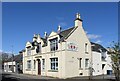
3
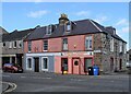
Former Argyle Bar
This building on the corner of Gilbert Street and Grant Street has the look of having once been a bar, though it is now private housing.
Update: I am grateful to Lynn Mackay, who has been in touch to inform me that the building was at one time the Argyle Bar. It is a listed building, and has been converted into flats.
Image: © Richard Dorrell
Taken: 9 Apr 2009
0.02 miles
4
'New' Ness Bridge
The 'old' bridge was swept away by floods in 1990. This utilitarian replacement straddles the border of two grid squares but the northern span shown here is in Image
Image: © Stephen Craven
Taken: 19 Jul 1996
0.02 miles
5
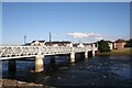
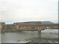
Waterloo Bridge
The Waterloo Bridge over the Ness.
Image: © Andrew Wood
Taken: 27 Jul 2011
0.02 miles
6
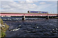
Train crossing the Ness Viaduct
A ScotRail Class 158 (number 158707) heading north across the bridge over the River Ness.
Image: © Craig Wallace
Taken: 20 Sep 2018
0.03 miles
7
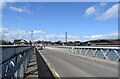
Crossing Waterloo Bridge, Inverness
The bridge is not listed but it has a Canmore listing (12248 https://canmore.org.uk/site/13348/inverness-waterloo-bridge ), which states that it was built in 1896 and the piers were constructed by the local Rose Street Foundry.
Image: © Bill Harrison
Taken: 12 Apr 2024
0.03 miles
8
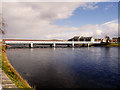
River Ness, Waterloo Bridge
Waterloo Bridge at Inverness.
The city of Inverness takes its name from the River Ness (Scottish Gaelic: Abhainn Nis) which is a relatively short river about 12 miles long flowing from the northern end of Loch Ness, through Loch Dochfour, to Inverness, where it discharges into the Beauly Firth. The origin of the name Inverness is from the Scottish Gaelic: Inbhir Nis, meaning "Mouth of the Ness".
Image: © David Dixon
Taken: 4 Apr 2017
0.04 miles
9
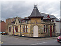
Merkinch Welfare Hall
At 30 Grant Street, next to the junction with Brown Street. The welfare hall was built in 1914 for the Catch-my-Pal Union, a temperance organisation. The drum clock was originally on the town steeple, before it was brought here in 1931.
After lying derelict for a number of years, the hall was restored in 2017. It is now in use by Inverness City Boxing Club and Merkinch Partnership.
It is a Category C listed building. http://portal.historicenvironment.scot/designation/LB43488
For another view, see Image
A similar view from 2011 Image
Image: © Craig Wallace
Taken: 20 Sep 2018
0.04 miles
10
Merkinch Welfare Hall, Grant Street, Inverness
The former temperance hall with its "enormous and decorative projecting clock" dates from ca. 1914 and is C-listed (LB43488 https://portal.historicenvironment.scot/designation/LB43488 ).
Image: © Bill Harrison
Taken: 12 Apr 2024
0.04 miles