IMAGES TAKEN NEAR TO
Seapark Road, FORRES, IV36 3TJ
Introduction
This page details the photographs taken nearby to Seapark Road, IV36 3TJ by members of the Geograph project.
The Geograph project started in 2005 with the aim of publishing, organising and preserving representative images for every square kilometre of Great Britain, Ireland and the Isle of Man.

There are currently over 7.5m images from over14,400 individuals and you can help contribute to the project by visiting https://www.geograph.org.uk
Image Map
Images are licensed for reuse under creativecommons.org/licenses/by-sa/2.0
Notes
- Clicking on the map will re-center to the selected point.
- The higher the marker number, the further away the image location is from the centre of the postcode.
Image Listing (43 Images Found)
Images are licensed for reuse under creativecommons.org/licenses/by-sa/2.0
Image
Details
Distance
1
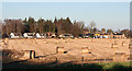
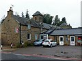
Sea Park
The old mansion house of Sea Park is behind the filling station next to the steading. The B9011 from Forres runs between the row of houses and the field with the bales in it.
Image: © Anne Burgess
Taken: 15 Jan 2013
0.01 miles
3
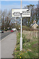
Old-fashioned Road Sign
This sign, dating from earlier days, has so far escaped removal, though it has been supplanted by modern signs
Image: © Anne Burgess
Taken: 13 Apr 2012
0.05 miles
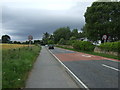
4
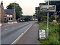
Road sign at Kinloss
A pre-Worboys sign, previously seen in 2012 https://www.geograph.org.uk/photo/2896630 but still in situ in 2019
Image: © Alan Murray-Rust
Taken: 18 Sep 2019
0.06 miles
6
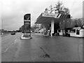
Study of a Gasoline Station
Gleaner, Kinloss.
Image: © David Bremner
Taken: 23 Apr 2023
0.08 miles
7
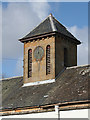
Clock Tower at Seapark
The clock tower on the west range of the stables at Seapark balances Image] on the east range. Sadly, the clock is not working. It shows 11.00 but in fact it was about 16.00.
Image: © Anne Burgess
Taken: 13 Apr 2012
0.08 miles
8
Former stables to Sea Park House, west wing
This is the road side of the buildings seen here https://www.geograph.org.uk/photo/2337932 , where they have been converted for retail use. Dated 1868, Listed Category B http://portal.historicenvironment.scot/designation/LB8683
Image: © Alan Murray-Rust
Taken: 18 Sep 2019
0.08 miles
9
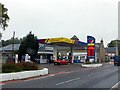
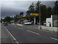
Sea Park filling station
Principally an oil distribution company, Gleaner also runs or supplies a network of filling stations across Scotland.
Image: © Alan Murray-Rust
Taken: 18 Sep 2019
0.09 miles
10

Former Sea Park Stables
Dated 1868, a substantial castellated stable/carriage house complex built around a courtyard. Grade B listed building.
Image: © Jean Aldridge
Taken: 2 Apr 2011
0.09 miles