IMAGES TAKEN NEAR TO
Castlehill Road, FOCHABERS, IV32 7LA
Introduction
This page details the photographs taken nearby to Castlehill Road, IV32 7LA by members of the Geograph project.
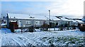
The Geograph project started in 2005 with the aim of publishing, organising and preserving representative images for every square kilometre of Great Britain, Ireland and the Isle of Man.

There are currently over 7.5m images from over14,400 individuals and you can help contribute to the project by visiting https://www.geograph.org.uk
Image Map
Images are licensed for reuse under creativecommons.org/licenses/by-sa/2.0
Notes
- Clicking on the map will re-center to the selected point.
- The higher the marker number, the further away the image location is from the centre of the postcode.
Image Listing (285 Images Found)
Images are licensed for reuse under creativecommons.org/licenses/by-sa/2.0
Image
Details
Distance
1
A Row of Gardens
In the Murrayfield/Castlehill housing estate.
Image: © Anne Burgess
Taken: 23 Apr 2021
0.01 miles
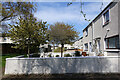
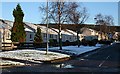
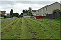
2
Castlehill Road
These are the backs of the council houses on Castlehill Road.
Image: © Anne Burgess
Taken: 19 Feb 2010
0.01 miles
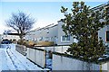
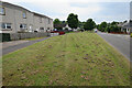
3
Castlehill
This is the largest council housing estate in Fochabers.
Image: © Anne Burgess
Taken: 7 Feb 2007
0.04 miles
4
Satellite Dishes!
Having seen the demise of the outside television aerials that used to adorn almost every rooftop, it seems a pity that they have been replaced by the equally unsightly phenomenon of satellite dishes on every upper storey.
Image: © Anne Burgess
Taken: 10 Jan 2021
0.04 miles
5

Lady's Smock (Cardamine pratensis)
Also known as Cuckoo Flower. There is quite a carpet of these in the grassy area in the housing estate. It's a pleasure to see them not just for themselves, but because they are the food plant of the Orange Tip butterfly. However I bet that within a day or two the council will have mowed the grass again, and with it all the wild flowers including these.
Image: © Anne Burgess
Taken: 23 Apr 2021
0.04 miles
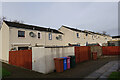
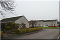
6
Sheltered Housing on Castlehill Road
Castlehill Road is actually behind these cottages in the housing development east of Ordiquish Road.
Image: © Anne Burgess
Taken: 19 Feb 2010
0.04 miles
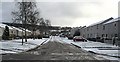
7
Castlehill
The sun is too low to illuminate more than the roofs of the low-rise council housing on the north side of Castlehill Road.
Image: © Anne Burgess
Taken: 7 Feb 2007
0.04 miles
8
Mown Mess
Such is the mania of Moray Council for mowing grass that the last lot of dead grass was still lying when it was mowed again, leaving these unsightly clods on the mown area.
Image: © Anne Burgess
Taken: 3 Jul 2021
0.04 miles
9
Ordiequish Road from Woodside Place
Looking out of the end of the spur of Woodside Place towards the houses on the east side of Ordiequish Road.
Image: © Anne Burgess
Taken: 28 Jan 2021
0.04 miles
10
A Mown Mess
Moray Council is obsessed with mowing grass, but what is the point of mowing it if they then leave the cut grass to rot in unsightly heaps? Even allowing that some people like to see mown grass, surely a swathe of Cuckoo Flower, Speedwell, Daisies, and Buttercups would look better than a mess like this? And it would be better for insects too.
Image: © Anne Burgess
Taken: 17 Jun 2021
0.04 miles