IMAGES TAKEN NEAR TO
Slorachs Brae, FOCHABERS, IV32 7HT
Introduction
This page details the photographs taken nearby to Slorachs Brae, IV32 7HT by members of the Geograph project.
The Geograph project started in 2005 with the aim of publishing, organising and preserving representative images for every square kilometre of Great Britain, Ireland and the Isle of Man.

There are currently over 7.5m images from over14,400 individuals and you can help contribute to the project by visiting https://www.geograph.org.uk
Image Map (Loading...)


Getting Data...Please wait
Leaflet Map data © OpenStreetMap
Images are licensed for reuse under creativecommons.org/licenses/by-sa/2.0
Notes
- Clicking on the map will re-center to the selected point.
- The higher the marker number, the further away the image location is from the centre of the postcode.
Image Listing (264 Images Found)
Images are licensed for reuse under creativecommons.org/licenses/by-sa/2.0
Image
Details
Distance
1
Milne Road
One of the maze of new streets in the housing development off Ordiequish Road.
Image: © Anne Burgess
Taken: 19 Feb 2010
0.01 miles
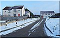
2
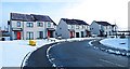
Slorach's Brae
Easily the steepest street in Fochabers. One of these days I will find out who the Slorach was who have his or her name to the woods and to this street.
Image: © Anne Burgess
Taken: 1 Jul 2021
0.01 miles
3
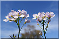
Lady's Smock (Cardamine pratensis)
Also known as Cuckoo Flower. There is quite a carpet of these in the grassy area in the housing estate. It's a pleasure to see them not just for themselves, but because they are the food plant of the Orange Tip butterfly. However I bet that within a day or two the council will have mowed the grass again, and with it all the wild flowers including these.
Image: © Anne Burgess
Taken: 23 Apr 2021
0.04 miles
4
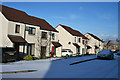
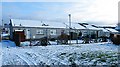
Milne Road
Although it's Friday, none of these cars seem to have moved since last night's snowfall.
Image: © Anne Burgess
Taken: 16 Jan 2015
0.04 miles
5
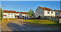
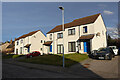
Sheltered Housing on Castlehill Road
Castlehill Road is actually behind these cottages in the housing development east of Ordiquish Road.
Image: © Anne Burgess
Taken: 19 Feb 2010
0.05 miles
6
Satellite Dishes!
Having seen the demise of the outside television aerials that used to adorn almost every rooftop, it seems a pity that they have been replaced by the equally unsightly phenomenon of satellite dishes on every upper storey.
Image: © Anne Burgess
Taken: 10 Jan 2021
0.05 miles
7
Milne Road
Semidetached houses on Milne Road, the highest-up street in Castlehill.
Image: © Anne Burgess
Taken: 23 Mar 2021
0.06 miles
8
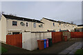
A Row of Gardens
In the Murrayfield/Castlehill housing estate.
Image: © Anne Burgess
Taken: 23 Apr 2021
0.06 miles
9

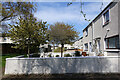
Castlehill Road
Modern terraced houses off Ordiequish Road.
Image: © Anne Burgess
Taken: 28 May 2021
0.06 miles
10
Slorach's Brae
This steeply sloping street is paved with protruding setts, making a rough surface so that it should be easier to get a car up to the top in winter weather.
Image: © Anne Burgess
Taken: 19 Feb 2010
0.06 miles