IMAGES TAKEN NEAR TO
John Street, LOSSIEMOUTH, IV31 6DE
Introduction
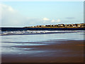
This page details the photographs taken nearby to John Street, IV31 6DE by members of the Geograph project.
The Geograph project started in 2005 with the aim of publishing, organising and preserving representative images for every square kilometre of Great Britain, Ireland and the Isle of Man.

There are currently over 7.5m images from over14,400 individuals and you can help contribute to the project by visiting https://www.geograph.org.uk
Image Map
Images are licensed for reuse under creativecommons.org/licenses/by-sa/2.0
Notes
- Clicking on the map will re-center to the selected point.
- The higher the marker number, the further away the image location is from the centre of the postcode.
Image Listing (91 Images Found)
Images are licensed for reuse under creativecommons.org/licenses/by-sa/2.0
Image
Details
Distance
1
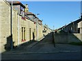
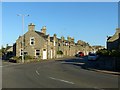
Carvel Street, Lossiemouth
Part of the 19th century grid-pattern development originally named Branderburgh which followed the improvement of the harbour between 1837 and 1860.
This is a one-sided street, the houses facing the backs of houses on Commerce Street.
Image: © Alan Murray-Rust
Taken: 21 Sep 2019
0.03 miles
2
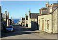
Brander Street, Lossiemouth
Named after Colonel James Brander of Pitgaveny who was responsible for the development of the harbour and Branderburgh, the grid-pattern section of what is now all Lossiemouth.
Image: © Alan Murray-Rust
Taken: 21 Sep 2019
0.05 miles
3
Approaching Lossiemouth on the Moray Coast Path
Image: © John Lucas
Taken: 26 Feb 2020
0.06 miles
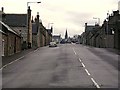
4
Queen Street, Lossiemouth
The main road (B9040) through the grid-pattern part of Lossiemouth, developed as Branderburgh during the latter part of the 19th century.
Image: © Alan Murray-Rust
Taken: 21 Sep 2019
0.06 miles
5
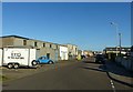
Shore Street, Lossiemouth
Commercial development associated with the harbour.
Image: © Alan Murray-Rust
Taken: 21 Sep 2019
0.07 miles
6
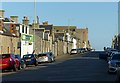
Queen Street, Lossiemouth
The main road (B9040) through the grid-pattern part of Lossiemouth, developed as Branderburgh during the latter part of the 19th century. It now forms the principal commercial street of the town.
Image: © Alan Murray-Rust
Taken: 21 Sep 2019
0.09 miles
7
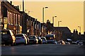
Queen Street, Lossiemouth
This was taken during a sunset with the rays of a low angled sun lighting up the buildings on the south side of the street.
Image: © Walter Baxter
Taken: 26 Aug 2014
0.10 miles
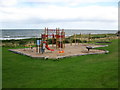
8
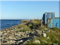
Coast at Lossiemouth
At the back of Shore Street, looking towards the harbour. The unweathered stones suggest that this is a man-made embankment rather than the natural shingle that can be found just a few tens of metres to the west http://www.geograph.org.uk/photo/6288922 .
Image: © Alan Murray-Rust
Taken: 21 Sep 2019
0.12 miles