IMAGES TAKEN NEAR TO
Queen Street, LOSSIEMOUTH, IV31 6BQ
Introduction
This page details the photographs taken nearby to Queen Street, IV31 6BQ by members of the Geograph project.
The Geograph project started in 2005 with the aim of publishing, organising and preserving representative images for every square kilometre of Great Britain, Ireland and the Isle of Man.

There are currently over 7.5m images from over14,400 individuals and you can help contribute to the project by visiting https://www.geograph.org.uk
Image Map (Loading...)


Getting Data...Please wait
Leaflet Map data © OpenStreetMap
Images are licensed for reuse under creativecommons.org/licenses/by-sa/2.0
Notes
- Clicking on the map will re-center to the selected point.
- The higher the marker number, the further away the image location is from the centre of the postcode.
Image Listing (61 Images Found)
Images are licensed for reuse under creativecommons.org/licenses/by-sa/2.0
Image
Details
Distance
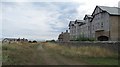
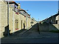
1
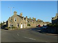
Queen Street, Lossiemouth
The main road (B9040) through the grid-pattern part of Lossiemouth, developed as Branderburgh during the latter part of the 19th century.
Image: © Alan Murray-Rust
Taken: 21 Sep 2019
0.03 miles
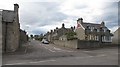
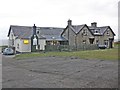
3
Brander Street, Lossiemouth
Named after Colonel James Brander of Pitgaveny who was responsible for the development of the harbour and Branderburgh, the grid-pattern section of what is now all Lossiemouth.
Image: © Alan Murray-Rust
Taken: 21 Sep 2019
0.08 miles
5
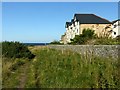
Stotfield Court, Lossiemouth
Apartment block overlooking the Moray Firth.
Image: © Alan Murray-Rust
Taken: 21 Sep 2019
0.11 miles
7
The Beach Bar at Lossiemouth
This was the public swimming baths but it is now a bar and restaurant.
Image: © Ann Harrison
Taken: 6 Aug 2009
0.11 miles
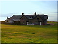
8
Links by Stotfield Road
A sandy track between Lossiemouth and the sea.
Image: © Richard Webb
Taken: 15 Aug 2018
0.11 miles
9
Carvel Street, Lossiemouth
Part of the 19th century grid-pattern development originally named Branderburgh which followed the improvement of the harbour between 1837 and 1860.
This is a one-sided street, the houses facing the backs of houses on Commerce Street.
Image: © Alan Murray-Rust
Taken: 21 Sep 2019
0.11 miles
10

What a view to wake up to
Morning view from a holiday let in Lossiemouth across the Moray Firth to the hills of Sutherland and Caithness.
Image: © Alan Murray-Rust
Taken: 21 Sep 2019
0.12 miles