IMAGES TAKEN NEAR TO
Smiddy Place, ELGIN, IV30 8XG
Introduction
This page details the photographs taken nearby to Smiddy Place, IV30 8XG by members of the Geograph project.
The Geograph project started in 2005 with the aim of publishing, organising and preserving representative images for every square kilometre of Great Britain, Ireland and the Isle of Man.

There are currently over 7.5m images from over14,400 individuals and you can help contribute to the project by visiting https://www.geograph.org.uk
Image Map
Images are licensed for reuse under creativecommons.org/licenses/by-sa/2.0
Notes
- Clicking on the map will re-center to the selected point.
- The higher the marker number, the further away the image location is from the centre of the postcode.
Image Listing (32 Images Found)
Images are licensed for reuse under creativecommons.org/licenses/by-sa/2.0
Image
Details
Distance
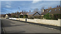
1
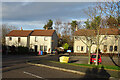
Smiddy Place
This small cul-de-sac just off the A96 in Crook of Alves is named for the smiddy that once stood here, roughly where the left-hand house now is.
Image: © Anne Burgess
Taken: 16 Nov 2020
0.01 miles
2
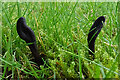
Earth Tongues (Geoglossum)
There were lots of these black fungi in the grass. As they mature, they twist and bend Image
Image: © Anne Burgess
Taken: 16 Nov 2020
0.03 miles
3
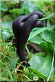
Earth Tongue (Geoglossum)
This is a more mature specimen of Image It makes me think of the German expression "Ich drücke Dir die Daumen" which means "I'll press my thumbs for you", the equivalent good luck wish to the English "I'll keep my fingers crossed for you".
Image: © Anne Burgess
Taken: 16 Nov 2020
0.03 miles
4
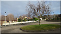
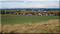
Carden Close
Carden Place is a development of modern bungalows on the outskirts of the village of Crook of Alves. It includes this large turning circle.
Image: © Anne Burgess
Taken: 2 Mar 2020
0.03 miles
5
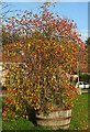
Rose Bush
A rose bush, growing in a repurposed whisky cask, has produced a proliferation of scarlet rose hips.
Image: © Anne Burgess
Taken: 16 Nov 2020
0.04 miles
7
Carden Close
Carden Close is a development of modern bungalows on the outskirts of the village of Crook of Alves. This home owner has managed to acquire a red telephone kiosk to decorate the garden.
Image: © Anne Burgess
Taken: 2 Mar 2020
0.05 miles
8
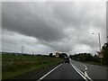
Crook of Alves
Although named simply as Alves on maps these days, older maps use the full name, Crook of Alves. From here, one is blissfully unaware of the busy A96 that carries heavy traffic along the edge of the village. The conspicuous green domes in the distance are biomass digesters at Wester Alves Farm. The name is pronounced AH-viss, by the way - the 'l' is silent and it has two syllables. Not 'alvz'.
Image: © Anne Burgess
Taken: 25 Feb 2020
0.06 miles
9
Carden Close
Carden Place is a development of modern bungalows on the outskirts of the village of Crook of Alves.
Image: © Anne Burgess
Taken: 2 Mar 2020
0.07 miles
10

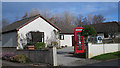
The Crooked Inn
The full name of the village of Alves was Crook of Alves, the word 'crook' referring presumably to the corner where the Burghead Road joins the main road. The inn was appropriately called the Crook Inn, being on that corner. However it changed hands in the 1980s and was renamed the Crooked Inn, thereby discarding part of its history.
Image: © Anne Burgess
Taken: 1 Mar 2011
0.08 miles