IMAGES TAKEN NEAR TO
Templand Road, ELGIN, IV30 8PP
Introduction
This page details the photographs taken nearby to Templand Road, IV30 8PP by members of the Geograph project.
The Geograph project started in 2005 with the aim of publishing, organising and preserving representative images for every square kilometre of Great Britain, Ireland and the Isle of Man.

There are currently over 7.5m images from over14,400 individuals and you can help contribute to the project by visiting https://www.geograph.org.uk
Image Map (Loading...)


Getting Data...Please wait
Leaflet Map data © OpenStreetMap
Images are licensed for reuse under creativecommons.org/licenses/by-sa/2.0
Notes
- Clicking on the map will re-center to the selected point.
- The higher the marker number, the further away the image location is from the centre of the postcode.
Image Listing (12 Images Found)
Images are licensed for reuse under creativecommons.org/licenses/by-sa/2.0
Image
Details
Distance
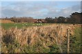
2
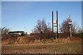
Electricity Transformer
This small transformer stands in the corner of a field south of Lhanbryde, some of the roofs of which can be seen in the background.
Image: © Anne Burgess
Taken: 17 Jan 2016
0.11 miles
5

November Sunset
When I emerged from the Co-Op in Lhanbryde, it was obvious that there was going to be a good sunset, and equally obvious that it would be past its best by the time I got home. This was the view from just beside the railway bridge east of the village.
Image: © Anne Burgess
Taken: 12 Nov 2020
0.16 miles
6
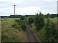
Railway Bridge near Lhanbryde
The bridge at the centre of this view carries the Aberdeen to Inverness railway line over a burn. Beyond the railway are some of the modern houses on the eastern outskirts of Lhanbryde.
Image: © Anne Burgess
Taken: 24 Nov 2008
0.22 miles
7
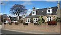
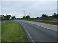
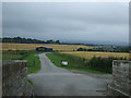
St Andrews Road, Lhanbryde
Houses on the north side of the main street of the village, now a peaceful spot since the village bypass was opened in 1995/6.
Image: © Anne Burgess
Taken: 5 Apr 2007
0.22 miles
8
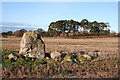
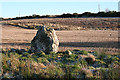
Bogton Stone Circle (2)
This is the more northerly of the two surviving orthostats of the stone circle. Most of the stones were removed in 1810. See https://canmore.org.uk/site/16524/bogton for more details. Image]
Image: © Anne Burgess
Taken: 17 Jan 2016
0.24 miles
9
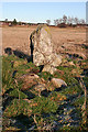
Bogton Stone Circle (3)
The standing stone is one of two remaining orthostats of the circle, the rest of which was demolished in 1810. See https://canmore.org.uk/site/16524/bogton for more details. Image]
Image: © Anne Burgess
Taken: 17 Jan 2016
0.24 miles
10
Bogton Stone Circle (9)
This is the more northerly of the two surviving orthostats, its fellows having been removed in 1810. See https://canmore.org.uk/site/16524/bogton for more details. Image]
Image: © Anne Burgess
Taken: 17 Jan 2016
0.24 miles