IMAGES TAKEN NEAR TO
The Terrace, ELGIN, IV30 8NY
Introduction
This page details the photographs taken nearby to The Terrace, IV30 8NY by members of the Geograph project.
The Geograph project started in 2005 with the aim of publishing, organising and preserving representative images for every square kilometre of Great Britain, Ireland and the Isle of Man.

There are currently over 7.5m images from over14,400 individuals and you can help contribute to the project by visiting https://www.geograph.org.uk
Image Map (Loading...)


Getting Data...Please wait
Leaflet Map data © OpenStreetMap
Images are licensed for reuse under creativecommons.org/licenses/by-sa/2.0
Notes
- Clicking on the map will re-center to the selected point.
- The higher the marker number, the further away the image location is from the centre of the postcode.
Image Listing (28 Images Found)
Images are licensed for reuse under creativecommons.org/licenses/by-sa/2.0
Image
Details
Distance
1
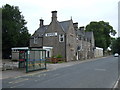
Tennant Arms Hotel, Lhanbryde
On St Andrew's Road.
Image: © JThomas
Taken: 20 Jul 2014
0.04 miles
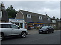
3

Lhanbryde.
The main street in Lhanbryde. The village has been bypassed for many years and is now very peaceful. I had a most interesting conversation with an elderly gentleman who was passing by as I took the photograph!!!
Image: © Christopher Gillan
Taken: 4 Jan 2006
0.05 miles
4
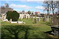
Lhanbryde Old Churchyard
Looking across from the south-eastern corner of the churchyard to Walkers Crescent and the new housing beyond.
Image: © Anne Burgess
Taken: 5 Apr 2007
0.05 miles
5
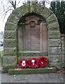
Lhanbryde War Memorial
The war memorial is hafl-way up the steps from St Andrew's Road to the old kirkyard. It was designed by John Wittet and built in 1920.
Image: © Anne Burgess
Taken: 6 Mar 2021
0.08 miles
6
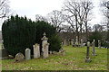
Lhanbryde Old Kirkyard
The kirk here, dedicated to St Bride or St Bridget as the village and parish name suggests, was first mentioned in the early 13th century, and was demolished in 1796.
Image: © Anne Burgess
Taken: 6 Mar 2021
0.08 miles
7
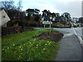
Lhanbryde
Entering Lhanbryde from the West. The village used to be on the main Aberdeen/Inverness road but is now fortunately bypassed.
Image: © Christopher Gillan
Taken: 11 Apr 2006
0.08 miles
8
Craig Enclosure
This is one of two enclosures built against the north wall of the old kirkyard at Lhanbryde. The stones commemorate members of the family of Thomas Young, farmer at Barmuckity, and his wife Helen Young.
Image: © Anne Burgess
Taken: 6 Mar 2021
0.08 miles
9
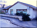
A Dwelling at Kirkhill Drive.
Kirkhill drive is a cul-de-sac of modern bungalows, each one different from the rest.
Image: © Ann Harrison
Taken: 12 Feb 2012
0.08 miles
10
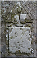
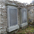
Innes Enclosure (3)
The Innes Enclosure is a Category A Listed building in the old kirkyard at Lhanbryde. This tablet, to the right of the effigy in Image], commemorates Maria Gordon, who died in 1647, wife of Sir Alexander Innes who completed Coxton Tower.
Image: © Anne Burgess
Taken: 6 Mar 2021
0.09 miles