IMAGES TAKEN NEAR TO
Grant Street, ELGIN, IV30 5UQ
Introduction
This page details the photographs taken nearby to Grant Street, IV30 5UQ by members of the Geograph project.
The Geograph project started in 2005 with the aim of publishing, organising and preserving representative images for every square kilometre of Great Britain, Ireland and the Isle of Man.

There are currently over 7.5m images from over14,400 individuals and you can help contribute to the project by visiting https://www.geograph.org.uk
Image Map
Images are licensed for reuse under creativecommons.org/licenses/by-sa/2.0
Notes
- Clicking on the map will re-center to the selected point.
- The higher the marker number, the further away the image location is from the centre of the postcode.
Image Listing (83 Images Found)
Images are licensed for reuse under creativecommons.org/licenses/by-sa/2.0
Image
Details
Distance
1
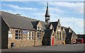
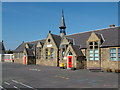
Burghead Primary School
The primary school, and now also the library, are housed in this attractive stone building. For another view see Image Unfortunately Image] is not quite so pleasing to the eye.
Image: © Anne Burgess
Taken: 30 Sep 2010
0.03 miles
2
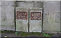
Water Markers
I take it that LMWB stands for Laich of Moray Water Board, which ceased to exist when it was subsumed into the North-East of Scotland Water Board when the Water (Scotland) Act 1967 came into force.
Image: © Anne Burgess
Taken: 19 Dec 2020
0.03 miles
3
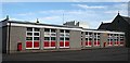
School Extension
Whoever designed this extension, now becoming decidedly shabby, to the attractive old school building had evidently no artistic or aesthetic sensibility. To add insult to injury, the top of the maltings looms over the top of it.
Image: © Anne Burgess
Taken: 30 Sep 2010
0.05 miles
4
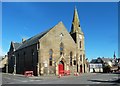
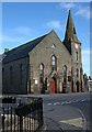
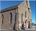
A Church In Burghead
This Church of Scotland building is located on Grant Street.
Image: © Mary and Angus Hogg
Taken: 24 Mar 2015
0.06 miles
5
Burghead Primary School
Note the unsightly modern extension on the left of the building.
Image: © Richard Slessor
Taken: 16 Sep 2006
0.07 miles
6
Church of Scotland
This isn't the parish kirk, because Burghead is in the parish of Duffus, and the parish kirk was originally in the village of Duffus in Image This one was built in 1901-2 to a design by Elgin architects A and W Reid and Wittet. It is now a linked charge with Kinloss.
Image: © Anne Burgess
Taken: 30 Sep 2010
0.07 miles
8
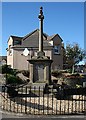
Burghead War Memorial
The war memorial stands in a small area of garden in the junction of Grant Street and Granary Street.
Image: © Anne Burgess
Taken: 30 Sep 2010
0.08 miles
9
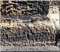
Burghead, parish church
This rivet and cut mark is on the north-west facing wall of the church, on the east side of Park Street. The rivet is very obvious, although the cut mark is now quite worn.
Image: © Mel Towler
Taken: 1 Jul 2021
0.08 miles
10
Burghead, parish church
A woder angle showing the parish church of Burghead with a rivet and cut mark on the north-west facing wall of the church, on the east side of Park Street. The rivet is very obvious, although the cut mark is now quite worn.
Image: © Mel Towler
Taken: 1 Jul 2021
0.08 miles