IMAGES TAKEN NEAR TO
Station Road, ELGIN, IV30 5UN
Introduction
This page details the photographs taken nearby to Station Road, IV30 5UN by members of the Geograph project.
The Geograph project started in 2005 with the aim of publishing, organising and preserving representative images for every square kilometre of Great Britain, Ireland and the Isle of Man.

There are currently over 7.5m images from over14,400 individuals and you can help contribute to the project by visiting https://www.geograph.org.uk
Image Map (Loading...)


Getting Data...Please wait
Leaflet Map data © OpenStreetMap
Images are licensed for reuse under creativecommons.org/licenses/by-sa/2.0
Notes
- Clicking on the map will re-center to the selected point.
- The higher the marker number, the further away the image location is from the centre of the postcode.
Image Listing (121 Images Found)
Images are licensed for reuse under creativecommons.org/licenses/by-sa/2.0
Image
Details
Distance
2
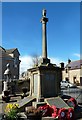
Burghead War Memorial
At first, I thought that this was a Mercat Cross but I found it to be a war memorial.
Image: © Mary and Angus Hogg
Taken: 24 Mar 2015
0.04 miles
3
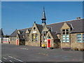
Burghead Primary School
Note the unsightly modern extension on the left of the building.
Image: © Richard Slessor
Taken: 16 Sep 2006
0.04 miles
5
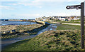
Approaching Burghead Harbour
The harbour was once served by rail with a spur from the Alves to Hopeman branch line
Image: © John Lucas
Taken: 27 Feb 2020
0.05 miles
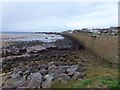
7
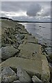
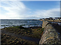
Sea defences, Burghead, Morayshire
WWII Anti-tank blocks have been reused to reduce erosion. A second row can be seen in the water.
Image: © Claire Pegrum
Taken: 16 Oct 2020
0.05 miles
8
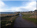
Burghead
Near the caravan site is the junction of various waymarked paths, including the popular walks to Findhorn via Roseisle. The sea wall extends right along the back of the beach to the harbour in the distance, with the village itself set higher and further back from the sea.
Image: © Anne Burgess
Taken: 17 Jan 2015
0.06 miles
9
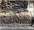
Burghead, parish church
This rivet and cut mark is on the north-west facing wall of the church, on the east side of Park Street. The rivet is very obvious, although the cut mark is now quite worn.
Image: © Mel Towler
Taken: 1 Jul 2021
0.06 miles
10
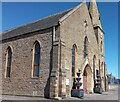
Burghead, parish church
A woder angle showing the parish church of Burghead with a rivet and cut mark on the north-west facing wall of the church, on the east side of Park Street. The rivet is very obvious, although the cut mark is now quite worn.
Image: © Mel Towler
Taken: 1 Jul 2021
0.06 miles