IMAGES TAKEN NEAR TO
Grant Street, ELGIN, IV30 5TZ
Introduction
This page details the photographs taken nearby to Grant Street, IV30 5TZ by members of the Geograph project.
The Geograph project started in 2005 with the aim of publishing, organising and preserving representative images for every square kilometre of Great Britain, Ireland and the Isle of Man.

There are currently over 7.5m images from over14,400 individuals and you can help contribute to the project by visiting https://www.geograph.org.uk
Image Map
Images are licensed for reuse under creativecommons.org/licenses/by-sa/2.0
Notes
- Clicking on the map will re-center to the selected point.
- The higher the marker number, the further away the image location is from the centre of the postcode.
Image Listing (285 Images Found)
Images are licensed for reuse under creativecommons.org/licenses/by-sa/2.0
Image
Details
Distance
1
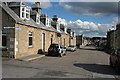
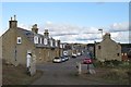
Grant Street
The 1:50,000 map colours Grant Street in yellow and Granary Street, which terminates at the harbour, in brown, as the B9013. In terms of the town layout, however, it is Grant Street which is the principal street of the town, running arrow-straight from the outskirts to the promontory at the seaward end.
Image: © Anne Burgess
Taken: 30 Sep 2010
0.01 miles
2
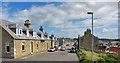
Grant Street
Burghead is a planned village. The traditional cottages are set along straight wide streets.
Image: © Anne Burgess
Taken: 22 May 1983
0.01 miles
3
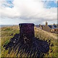
Doorie Hill
The destination of the flaming Clavie ceremony which takes place every year on the 11th of January http://www.burghead.com/clavie/
Image: © valenta
Taken: 22 Sep 2018
0.02 miles
4
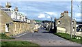
Grant Street, Burghead
Viewed from the western end of the road, at its junction with Bath Street.
Image: © Richard Dorrell
Taken: 8 Aug 2016
0.02 miles
6
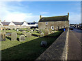
Burial Ground in Grant Street, Burghead
Possibly associated with the now lost St Aethan's Chapel. Canmore: https://canmore.org.uk/site/16201/burghead-grant-street-old-burial-ground-and-st-aethans-chapel
Image: © John Lucas
Taken: 27 Feb 2020
0.02 miles
7

Burghead town
Looking down the Burghead peninsula from the lookout point and site of the Pictish broch. The memorial stone reads:
"In honour of all Brochers lost at sea in peace and war".
Image: © Oliver Dixon
Taken: 16 Sep 2016
0.02 miles
8
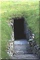
Burghead Well
This is the entrance to the underground pool known as Burghead Well. No-one really knows when it was built and by whom.
Image: © Anne Burgess
Taken: 22 May 1983
0.03 miles
9
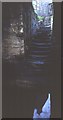
Burghead Well
A flight of steps leads down to an underground pool. The purpose of the structure is unknown.
Image: © Anne Burgess
Taken: 22 May 1983
0.03 miles
10
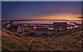
Burghead Sunset
A striking orange sunset over Burghead, to see 2019 out
Image: © valenta
Taken: 31 Dec 2019
0.03 miles