IMAGES TAKEN NEAR TO
Duffus, ELGIN, IV30 5RF
Introduction
This page details the photographs taken nearby to IV30 5RF by members of the Geograph project.
The Geograph project started in 2005 with the aim of publishing, organising and preserving representative images for every square kilometre of Great Britain, Ireland and the Isle of Man.

There are currently over 7.5m images from over14,400 individuals and you can help contribute to the project by visiting https://www.geograph.org.uk
Image Map
Images are licensed for reuse under creativecommons.org/licenses/by-sa/2.0
Notes
- Clicking on the map will re-center to the selected point.
- The higher the marker number, the further away the image location is from the centre of the postcode.
Image Listing (15 Images Found)
Images are licensed for reuse under creativecommons.org/licenses/by-sa/2.0
Image
Details
Distance
1
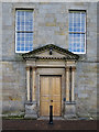
Main Door
Originally the main approach to Gordonstoun was via an arrow-straight drive from the north-northwest towards this door. Now, however, the approach is from either east or west, and this door looks as if it is never used. The present entrance is to the right of the view.
Image: © Anne Burgess
Taken: 18 Oct 2016
0.10 miles
2
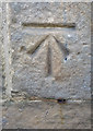
Ordnance Survey Cut Mark
This is on the west end of the north façade of Gordonstoun House.
Image: © Anne Burgess
Taken: 18 Oct 2016
0.11 miles
3
Gordonstoun House
The house dates back in part to the sixteenth century, but the present elevation is mainly 18th century. It is the centre of Gordonstoun School. See https://canmore.org.uk/site/16143/gordonstoun-house for details.
Image: © Anne Burgess
Taken: 18 Oct 2016
0.11 miles
4
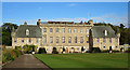
Gordonstoun House
The nerve centre of the famous school is the house, which dates mainly from the 18th century, though there are earlier parts, including the two wings. See https://canmore.org.uk/site/16143/gordonstoun-house for details.
Image: © Anne Burgess
Taken: 18 Oct 2016
0.11 miles
5
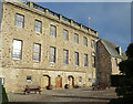
Gordonstoun House
The south elevation of the house reveals some of its history. The central part was replaced in the 18th century following a fire, so the outer wings are older than the main block. At one time there was an extension at ground level, and vestiges of that can be seen in the various bricked-up doors, windows and archways. See https://canmore.org.uk/site/16143/gordonstoun-house for details.
Image: © Anne Burgess
Taken: 18 Oct 2016
0.11 miles
6
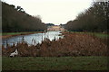
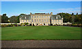
Beyond the pond to Gordonstoun school
A universally renowned centre of education and arguably the mecca of the Tiny Toff.
Image: © Des Colhoun
Taken: 26 Dec 2008
0.12 miles
7
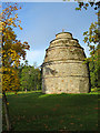
Gordonstoun Doocot
Apart from the type and quantity of encroaching vegetation, it hasn't changed much in the 33 years since Image] was taken. See https://canmore.org.uk/site/16113/gordonstoun-house-round-square-dovecot
Image: © Anne Burgess
Taken: 18 Oct 2016
0.14 miles
8
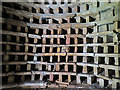
Gordonstoun Doocot
Inside the doocot, showing some of the hundreds of pigeon holes. See https://canmore.org.uk/site/16113/gordonstoun-house-round-square-dovecot for details.
Image: © Anne Burgess
Taken: 18 Oct 2016
0.14 miles
9
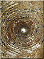
Gordonstoun Doocot
Looking straight up to the hole at the top through which the doos would have gained access to the nest boxes. The hole is now obstructed by wire netting to keep them out. See https://canmore.org.uk/site/16113/gordonstoun-house-round-square-dovecot. Taken with the camera lying on the centre of the floor. Each of the circles is the underside of a tier of pigeon holes.
Image: © Anne Burgess
Taken: 18 Oct 2016
0.14 miles
10
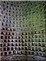
Gordonstoun Doocot
Tiers of pigeon holes inside the beehive doocot at Gordonstoun. See https://canmore.org.uk/site/16113/gordonstoun-house-round-square-dovecot for details.
Image: © Anne Burgess
Taken: 18 Oct 2016
0.14 miles