IMAGES TAKEN NEAR TO
Spynie Street, ELGIN, IV30 4JS
Introduction
This page details the photographs taken nearby to Spynie Street, IV30 4JS by members of the Geograph project.
The Geograph project started in 2005 with the aim of publishing, organising and preserving representative images for every square kilometre of Great Britain, Ireland and the Isle of Man.

There are currently over 7.5m images from over14,400 individuals and you can help contribute to the project by visiting https://www.geograph.org.uk
Image Map (Loading...)


Getting Data...Please wait
Leaflet Map data © OpenStreetMap
Images are licensed for reuse under creativecommons.org/licenses/by-sa/2.0
Notes
- Clicking on the map will re-center to the selected point.
- The higher the marker number, the further away the image location is from the centre of the postcode.
Image Listing (13 Images Found)
Images are licensed for reuse under creativecommons.org/licenses/by-sa/2.0
Image
Details
Distance
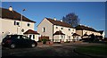
1
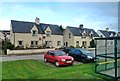
Cameron Road
Housing area viewed from Lossiemouth Road in late October.
Image: © Mary and Angus Hogg
Taken: 26 Oct 2014
0.10 miles
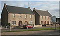
2
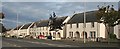
Harrison Terrace
This row of houses is a Category B listed building. It was designed by John P M Wright in 1947, and building commenced in 1949. The arched doorways recall the arched 'piazzas' which formerly lined the High Street in Elgin, but have mostly been lost. The houses were built by Elgin Town Council, and demonstrate that it is possible to build attractive council housing in traditional style. The row is named after Provost Edward Harrison, who was keen to incorporate traditional vernacular elements.
Image: © Anne Burgess
Taken: 20 Sep 2010
0.12 miles
3
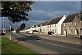
Lossiemouth Road
On the right as one heads towards Lossiemouth is Harrison Terrace. This is where the speed limit increases from 30 to 40 mph, rather surprisingly because there are still large residential areas on both sides of the road.
Image: © Anne Burgess
Taken: 20 Sep 2010
0.13 miles
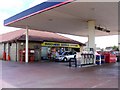
5
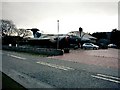
RAF Buccaneer at Filling Station in Elgin
A retired Buccaneer graces the forecourt of a filling station on the outskirts of Elgin on the road to Lossie. These magnificent planes flew from nearby RAF Lossiemouth until 1994.
Image: © Christopher Gillan
Taken: 4 Dec 2005
0.14 miles
6
Argus Place
Ministry of Defence housing built for RAF service personnel and their families.
Image: © Anne Burgess
Taken: 28 Nov 2008
0.16 miles
7
Harrison Terrace
This row of houses is a Category B listed building. It was designed by John P M Wright in 1947, and building commenced in 1949. The arched doorways recall the arched 'piazzas' which formerly lined the High Street in Elgin, but have mostly been lost. The houses were built by Elgin Town Council, and demonstrate that it is possible to build attractive council housing in traditional style. The row is named after Provost Edward Harrison, who was keen to incorporate traditional vernacular elements. Sadly, some of the new owners have altered their windows, which has destroyed the unity and symmetry of the original design.
Image: © Anne Burgess
Taken: 20 Sep 2010
0.20 miles
8
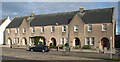
Harrison Terrace
This row of houses is a Category B listed building. It was designed by John P M Wright in 1947, and building commenced in 1949. The arched doorways recall the arched 'piazzas' which formerly lined the High Street in Elgin, but have mostly been lost. The houses were built by Elgin Town Council, and demonstrate that it is possible to build attractive council housing in traditional style. The row is named after Provost Edward Harrison, who was keen to incorporate traditional vernacular elements. There are blocks containing 2, 4 and 8 houses. This one is a 4-house block.
Image: © Anne Burgess
Taken: 20 Sep 2010
0.20 miles
9
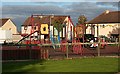
Nelson Square
The centre of Nelson Square is occupied by a play area, depressingly deserted at quarter to six in the evening on a dry sunny schoolday.
Image: © Anne Burgess
Taken: 20 Sep 2010
0.21 miles
10
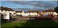
Nelson Square
In the background are the houses on Hermes Road. Nelson Square is a gap between Lossiemouth Road and Hermes Road, but there is no direct access from it to Lossiemouth Road, which keeps it relatively free of traffic. The large sign used to say that the play area is for use of children under 14, and lists equipment and activities which are forbidden, but many of the letters have fallen off, giving it a rather scruffy appearance.
Image: © Anne Burgess
Taken: 20 Sep 2010
0.21 miles