IMAGES TAKEN NEAR TO
Ardersier, INVERNESS, IV2 7QU
Introduction
This page details the photographs taken nearby to IV2 7QU by members of the Geograph project.
The Geograph project started in 2005 with the aim of publishing, organising and preserving representative images for every square kilometre of Great Britain, Ireland and the Isle of Man.

There are currently over 7.5m images from over14,400 individuals and you can help contribute to the project by visiting https://www.geograph.org.uk
Image Map
Images are licensed for reuse under creativecommons.org/licenses/by-sa/2.0
Notes
- Clicking on the map will re-center to the selected point.
- The higher the marker number, the further away the image location is from the centre of the postcode.
Image Listing (9 Images Found)
Images are licensed for reuse under creativecommons.org/licenses/by-sa/2.0
Image
Details
Distance
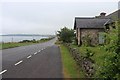
2
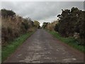
Highland : Old Military Road, B9039
Looking along Old Military Road.
Image: © Lewis Clarke
Taken: 23 Apr 2016
0.02 miles
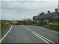
3
Highland : Old Military Road, B9039
Looking along the Old Military Road.
Image: © Lewis Clarke
Taken: 23 Apr 2016
0.05 miles
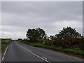
6
Field at Connage towards Inverness Airport
Image: © Douglas Nelson
Taken: 6 Oct 2018
0.11 miles
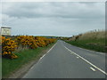
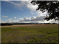
7
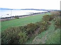
Near Mains of Connage
The viewpoint here is on top of the raised beach which runs along much of the coast here, about 10 metres above the present sea level. The cultivable land in the foreground has been formed since the last Ice Age, that is, in the last 10,000 years or so.
Image: © Anne Burgess
Taken: 27 Feb 2013
0.17 miles
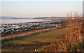
8
Shore at Ardersier
It's probably just as well that the foreshore west of Ardersier is rocky, seaweedy and maybe a bit muddy, because I can think of few better ways of disfiguring a beach than putting a power line along it. At least the wading birds don't seem to mind the telegraph poles.
Image: © Anne Burgess
Taken: 26 Dec 2017
0.17 miles
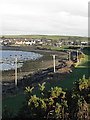
9
Shoreline south of Ardersier
A good example of raised beach topography.
Image: © John Allan
Taken: 16 Jan 2007
0.20 miles