IMAGES TAKEN NEAR TO
Old Perth Road, INVERNESS, IV2 3UP
Introduction
This page details the photographs taken nearby to Old Perth Road, IV2 3UP by members of the Geograph project.
The Geograph project started in 2005 with the aim of publishing, organising and preserving representative images for every square kilometre of Great Britain, Ireland and the Isle of Man.

There are currently over 7.5m images from over14,400 individuals and you can help contribute to the project by visiting https://www.geograph.org.uk
Image Map
Images are licensed for reuse under creativecommons.org/licenses/by-sa/2.0
Notes
- Clicking on the map will re-center to the selected point.
- The higher the marker number, the further away the image location is from the centre of the postcode.
Image Listing (36 Images Found)
Images are licensed for reuse under creativecommons.org/licenses/by-sa/2.0
Image
Details
Distance

2
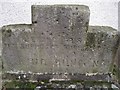
King Duncan buried here?
This carved stone stands on the corner of Culcabock Avenue, in front of an area of ground formerly known as King Duncan's Hollow. The inscription reads: 'Behind this is the supposed burial place of King Duncan 1140.' However, an archaeological evaluation was undertaken in February 2002 in advance of the refurbishment and extension of an existing service station. The area known as King Duncan's Hollow is marked on the 1st edition OS map (1868) as the 'Supposed site of King Duncan's Grave'. There is no evidence for the source of this association and no archaeologically significant deposits were identified in the course of the evaluation. (Information from The Royal Commission on the Ancient and Historical Monuments of Scotland).
Wider view: Image
Image: © Richard Dorrell
Taken: 23 Nov 2011
0.03 miles
3
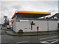
Site of King Duncan's Hollow
The carved stone on the pavement close to the corner of the building is inscribed to suggest that this is the site of the grave of King Duncan. See detail for more information: Image] . If he is buried here, he will be handily placed for the petrol station shop which now stands over King Duncan's Hollow.
Image: © Richard Dorrell
Taken: 23 Nov 2011
0.04 miles
4
Raigmore Motel
A small motel in Old Perth Road.
Image: © Richard Dorrell
Taken: 30 Jun 2009
0.04 miles
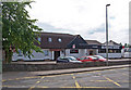
5

Psychological Service, Culcabock Centre
Formerly Culcabock Primary School, and located in Culcabock Avenue, the building is now the Inverness Division offices of the Highland Regional Council's Psychological Services.
Image: © Richard Dorrell
Taken: 23 Nov 2011
0.06 miles
7

Raigmore Avenue
A residential cul de sac close to Raigmore hospital.
Image: © Richard Dorrell
Taken: 30 Jun 2009
0.07 miles
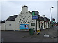
8
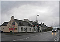
The Fluke public house, Inverness
Once known as The New Market Inn, the pub is located in Culcabock Road.
Image: © Richard Dorrell
Taken: 23 Nov 2011
0.08 miles
9
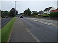
Old Perth Road. (B9006)
Heading north west.
Image: © JThomas
Taken: 19 Jul 2014
0.09 miles
10
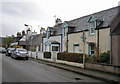
Housing in Culcabock Avenue
The road is lined with a variety of small houses mostly dating from the 19th century.
Image: © Richard Dorrell
Taken: 23 Nov 2011
0.11 miles