IMAGES TAKEN NEAR TO
Cromarty Drive, INVERGORDON, IV18 0PY
Introduction
This page details the photographs taken nearby to Cromarty Drive, IV18 0PY by members of the Geograph project.
The Geograph project started in 2005 with the aim of publishing, organising and preserving representative images for every square kilometre of Great Britain, Ireland and the Isle of Man.

There are currently over 7.5m images from over14,400 individuals and you can help contribute to the project by visiting https://www.geograph.org.uk
Image Map
Images are licensed for reuse under creativecommons.org/licenses/by-sa/2.0
Notes
- Clicking on the map will re-center to the selected point.
- The higher the marker number, the further away the image location is from the centre of the postcode.
Image Listing (10 Images Found)
Images are licensed for reuse under creativecommons.org/licenses/by-sa/2.0
Image
Details
Distance

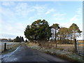
3
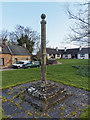
Milton Market Cross
Milton Market Cross said to date from 1799 and probably associated with the building of Tarbat House
Image: © valenta
Taken: 19 Mar 2017
0.14 miles
4

Ploughed Fields
This is a new type of furrow that I have not seen before, the rows are very defined and I would guess that it is for potatoes.
Image: © Dorcas Sinclair
Taken: 21 May 2005
0.16 miles
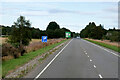
6
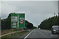
On the A9 passing Milton
This was a completely new section of road constructed during the upgrading of the A9 in the early 1980s.
Image: © Alan Murray-Rust
Taken: 16 Jun 1998
0.17 miles
9
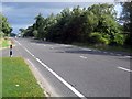
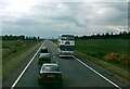
The A9 passing Milton
Heading for Kildary.
Image: © James Denham
Taken: 2 Sep 2013
0.24 miles
10
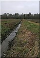
Former mill lade, Milton, Ross And Cromarty
Water for a corn mill at Milton was supplied via a lade diverted from the Balnagown River. At this point water had passed through the mill and was returning to the river which runs left to right in the trees. It is now labelled as a drain on larger scale Ordnance Survey maps.
Image: © Claire Pegrum
Taken: 13 Apr 2022
0.25 miles