IMAGES TAKEN NEAR TO
Upper Knockbain Road, DINGWALL, IV15 9NR
Introduction
This page details the photographs taken nearby to Upper Knockbain Road, IV15 9NR by members of the Geograph project.
The Geograph project started in 2005 with the aim of publishing, organising and preserving representative images for every square kilometre of Great Britain, Ireland and the Isle of Man.

There are currently over 7.5m images from over14,400 individuals and you can help contribute to the project by visiting https://www.geograph.org.uk
Image Map
Images are licensed for reuse under creativecommons.org/licenses/by-sa/2.0
Notes
- Clicking on the map will re-center to the selected point.
- The higher the marker number, the further away the image location is from the centre of the postcode.
Image Listing (11 Images Found)
Images are licensed for reuse under creativecommons.org/licenses/by-sa/2.0
Image
Details
Distance
1
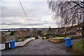
Knockbain Road
Looking east, downhill, towards Dingwall town.
Image: © Richard Dorrell
Taken: 22 Dec 2018
0.02 miles
3
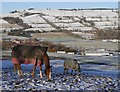
Horses in the snow, by Knockbain
A pair of horses, in a field next to the Knockbain road.
Looking across the industrial estate and business parks at the west end of Dingwall, with the hills around Dochcarty beyond, much of the area covered by snow.
Image: © Craig Wallace
Taken: 19 Jan 2015
0.12 miles
4
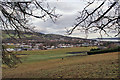
Over the fields towards Dingwall
Looking north east over fields and paddocks, with the small town of Dingwall beyond.
Image: © Richard Dorrell
Taken: 22 Dec 2018
0.13 miles
5
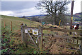
Path to Fodderty
At the western end of Knockbain Road, this gate leads onto a path which drops down the hill to meet the railway, and then follows the railway (and former railway) to Fodderty.
Image: © Richard Dorrell
Taken: 22 Dec 2018
0.13 miles
6
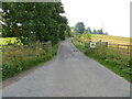
Track that gives access to Knockbain Farm
Looking westward.
Image: © Peter Wood
Taken: 28 Aug 2021
0.14 miles
7
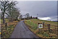
Approach to Knockbain Farm
There will be a tree or hedging shrub planted inside each of the light green plastic tubes to the right of the road - so this is a view that will change considerably over the coming years.
Image: © Richard Dorrell
Taken: 22 Dec 2018
0.14 miles
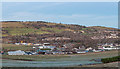
8
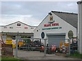
Retail area, Dingwall
Just over the railway, this out of town shopping area (near where the dairy used to be) reflects the local farming culture.
Image: © Richard Webb
Taken: 9 Aug 2005
0.23 miles
9
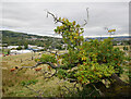
Tree, by Knockbain
A view from the low route to Knockbain Farm. An interesting twisted, leaning sweet chestnut tree (Castanea sativa).
Image: © Craig Wallace
Taken: 14 Sep 2020
0.24 miles
10
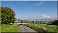
Descending to Dingwall from Knockbain
The Knockbain road gives a fine view overlooking Dingwall to the Cromarty Firth.
Image: © Julian Paren
Taken: 25 Sep 2017
0.24 miles