IMAGES TAKEN NEAR TO
STRATHPEFFER, IV14 9DH
Introduction
This page details the photographs taken nearby to IV14 9DH by members of the Geograph project.
The Geograph project started in 2005 with the aim of publishing, organising and preserving representative images for every square kilometre of Great Britain, Ireland and the Isle of Man.

There are currently over 7.5m images from over14,400 individuals and you can help contribute to the project by visiting https://www.geograph.org.uk
Image Map
Images are licensed for reuse under creativecommons.org/licenses/by-sa/2.0
Notes
- Clicking on the map will re-center to the selected point.
- The higher the marker number, the further away the image location is from the centre of the postcode.
Image Listing (152 Images Found)
Images are licensed for reuse under creativecommons.org/licenses/by-sa/2.0
Image
Details
Distance
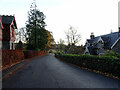
2
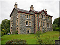
The Red House, Strathpeffer
This Category B listed house faces onto the A834 at the eastern end of Strathpeffer village. Built in the late 19th century as a pair of semi-detached houses, it is now all one house.
The house takes its name from the brick-coloured tiles and maroon joinery used in its construction. It is a rare example of a tile-hung Arts and Crafts style house in the Highlands.
The walling material recalls the style of architect George Devey, whose work was mostly in south east England.
Image: © Richard Dorrell
Taken: 2 Feb 2021
0.01 miles
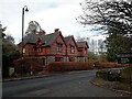
3
Victorian house, Strathpeffer
This imposing red house stands opposite to the entrance to Strathpeffer railway station and the Museum of Childhood.
Image: © Carol Walker
Taken: Unknown
0.02 miles
4
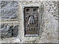
Ordnance Survey Flush Bracket G4468
This can be found on the wall of Newton Villa (a private dwelling) in Strathpeffer. The benchmark height is recorded as being 41.654 metres above sea level.
For more detail see : https://www.bench-marks.org.uk/bm11826
Image: © Peter Wood
Taken: 27 Sep 2018
0.03 miles
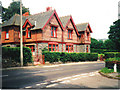
5
Burnhill, Strathpeffer
A three-storey house, next to the old railway station. It was built in 1888, for the inspector of schools.
Some details on the Highland Council HER. https://her.highland.gov.uk/Monument/MHG22284
Image: © Craig Wallace
Taken: 12 Sep 2021
0.03 miles
6
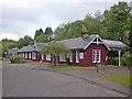
Former station approach, Strathpeffer
Image: © Roger Cornfoot
Taken: 3 Jun 2015
0.04 miles
8
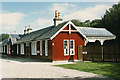
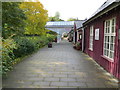
The Victorian Station at Strathpeffer
The arrival of the railways in Dingwall in 1862 did much to bring more visitors to Strathpeffer. In 1885 a branch line from the Kyle of Lochalsh Line was built and Strathpeffer railway station was opened on 3 June; the most logical route for the line was through the town, but disagreements with landowners initially prevented the railway from crossing their land. The branch closed in February 1946. The station now contains a variety of shops and craft outlets as well as the Highland Museum of Childhood. The station building itself is of classic Victorian architecture and still has the original platform which many shops front onto. The nearest stations are now in Dingwall and Garve.
The long single-storey, 12-bay station building at Strathpeffer is Category B listed (LB7834 http://portal.historicenvironment.scot/designation/LB7834 Historic Environment Scotland).
Image: © David Dixon
Taken: 23 Jun 2022
0.04 miles
9
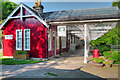
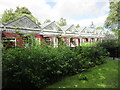
The restored Platform and Canopy at the former Strathpeffer Railway Station
Looking westward.
Image: © Peter Wood
Taken: 27 Sep 2018
0.04 miles
10
Former station, Strathpeffer
The railway station at Strathpeffer opened on 3rd June 1885 before closing to regular passenger traffic on 23rd February 1946. It now home to a number of craft shops.
Image: © Euan Nelson
Taken: 9 Aug 2016
0.04 miles