IMAGES TAKEN NEAR TO
Swanson Way, IP32 7QP
Introduction
This page details the photographs taken nearby to Swanson Way, IP32 7QP by members of the Geograph project.
The Geograph project started in 2005 with the aim of publishing, organising and preserving representative images for every square kilometre of Great Britain, Ireland and the Isle of Man.

There are currently over 7.5m images from over14,400 individuals and you can help contribute to the project by visiting https://www.geograph.org.uk
Image Map
Images are licensed for reuse under creativecommons.org/licenses/by-sa/2.0
Notes
- Clicking on the map will re-center to the selected point.
- The higher the marker number, the further away the image location is from the centre of the postcode.
Image Listing (29 Images Found)
Images are licensed for reuse under creativecommons.org/licenses/by-sa/2.0
Image
Details
Distance
1
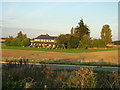
The Flying Fortress public house and restaurant
The Flying Fortress, on the northern edge of Rougham Airfield, is named after the main aircraft type based here in WW2. It is viewed here from the top of an earth mound made during the new estate construction, and across an estate road that does not yet appear on Geograph's Landranger map, now named Lady Miriam Way.
The pub, which was converted from a farmhouse, was known for its regular 'blog' in the local newspapers but closed some years ago. With much more house building in the area there are hopes that the owners, the brewers Greene King, may reopen it.
Image: © John Goldsmith
Taken: 6 Oct 2008
0.12 miles
2

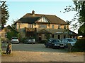
The Flying Fortress
As seen from a new road, looking away from Bury St Edmunds. This is a side view of the pub, the front being on the left in this photo.
Image: © Greg Aspland
Taken: 18 Oct 2008
0.12 miles
3
The Flying Fortress Pub
The Flying Fortress pub that was a farm house on the wartime airfield U.S.A.A.F. Rougham, Suffolk. For info on the airfield see http://en.wikipedia.org/wiki/RAF_Bury_St_Edmunds and for a close up view of the pub sign see http://www.geograph.org.uk/photo/1293867
Image: © Keith Evans
Taken: 8 May 2009
0.12 miles
5
The Flying Fortress, near Bury St Edmunds
This public house, at the end of a short lane, used to be 'in the sticks' a couple of miles outside the town. But modern housing development has now reached it and threatens to swallow it up. in the next few years.
Image: © Bob Jones
Taken: 5 Jul 2005
0.14 miles
6
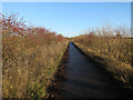
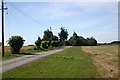
National cycle route 51
Between Bury St. Edmunds and Thurston.
Image: © Hugh Venables
Taken: 22 Dec 2016
0.15 miles
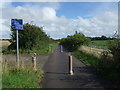
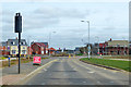
7
Lady Miriam Way
Part of Moreton Hall, a major and ongoing expansion of Bury St. Edmunds.
Image: © Hugh Venables
Taken: 22 Dec 2016
0.15 miles
9
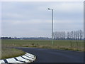
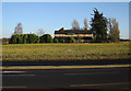
New Football Ground?
Beyond the roundabout at the top of Skyliner Way, a new road not yet shown on Landranger maps, are the open fields being earmarked by St Edmundsbury BC as the site for the future home of Bury Town FC.
Image: © Stuart Shepherd
Taken: 28 Jan 2009
0.15 miles
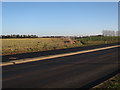
10
Roundabout on Mount Road, Bury St Edmunds
At the eastern limit, so far, of the new development extending the town to the east.
Image: © Robin Webster
Taken: 7 Mar 2020
0.16 miles