IMAGES TAKEN NEAR TO
Millfield Road, SOUTHWOLD, IP18 6UD
Introduction
This page details the photographs taken nearby to Millfield Road, IP18 6UD by members of the Geograph project.
The Geograph project started in 2005 with the aim of publishing, organising and preserving representative images for every square kilometre of Great Britain, Ireland and the Isle of Man.

There are currently over 7.5m images from over14,400 individuals and you can help contribute to the project by visiting https://www.geograph.org.uk
Image Map
Images are licensed for reuse under creativecommons.org/licenses/by-sa/2.0
Notes
- Clicking on the map will re-center to the selected point.
- The higher the marker number, the further away the image location is from the centre of the postcode.
Image Listing (146 Images Found)
Images are licensed for reuse under creativecommons.org/licenses/by-sa/2.0
Image
Details
Distance
1
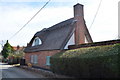
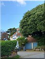
Thatched House in Walberswick
A nice attractive thatched house in Walberswick village. This part of the village boasts many old houses, this is why it is a conservation area.
Image: © Ashley Dace
Taken: 15 Mar 2010
0.03 miles
3
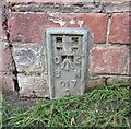
Walberswick, Main Street
The OS Flush Bracket 017S is embedded into the road side wall on the south of The Street which runs through the village. It is on the east of the junction with Millfield Road.
Image: © Mel Towler
Taken: 4 Jul 2022
0.07 miles
4
Walberswick, Main Street
There is OS Flush Bracket 017S embedded into the road side wall on the south of The Street which runs through the village. It is on the east of the junction with Millfield Road.
Image: © Mel Towler
Taken: 4 Jul 2022
0.07 miles
5
The Street, Walberswick
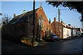
The nearest building was formerly a Methodist Chapel and has since been converted to a family house available to rent as a holiday home.
Image: © Hugh Venables
Taken: 29 Dec 2008
0.07 miles
6
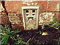
Flush Bracket OSBM S017 Walberswick Dudley Cottage
Flush Bracket OSBM S017 Walberswick Dudley Cottage, NW angle, S side of The Street.
Image: © Cud05
Taken: 28 Apr 2016
0.07 miles
7
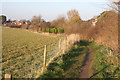
Footpath to Walberswick
From the marshes.
Image: © Hugh Venables
Taken: 29 Dec 2008
0.07 miles
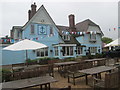
8
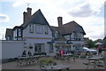
The Anchor, Walberswick
I had some Adnam's East Green, which was one of this year's two most delectable pints.
Image: © Bill Boaden
Taken: 29 Aug 2009
0.07 miles
9
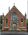
Walberswick : chapel
Former Primitive Methodist chapel. Converted into holiday accommodation following its closure. More at this https://www.genuki.org.uk/big/eng/SFK/Walberswick/Chapel.
"The first chapel was built in 1846. It was opened on Christmas Day and we are told about it by W Sapcoat in the Primitive Methodist magazine. The chapel was rebuilt in 1910." - https://www.myprimitivemethodists.org.uk/content/chapels/suffolk/s-z/walberswick-primitive-methodist-church. The Halesworth Times and East Suffolk Advertiser of 12 April 1910 reported on the memorial stone laying ceremony of the chapel, the architect of which was A.F. Scott. Augustus Frederic Scott, whose father was a Primitive Methodist minister, was a Norwich based architect : much of his work is to be found in Cromer.
Image: © Jim Osley
Taken: 30 Jun 2021
0.08 miles