IMAGES TAKEN NEAR TO
Rectory Road, WOODBRIDGE, IP13 7LQ
Introduction
This page details the photographs taken nearby to Rectory Road, IP13 7LQ by members of the Geograph project.
The Geograph project started in 2005 with the aim of publishing, organising and preserving representative images for every square kilometre of Great Britain, Ireland and the Isle of Man.

There are currently over 7.5m images from over14,400 individuals and you can help contribute to the project by visiting https://www.geograph.org.uk
Image Map
Images are licensed for reuse under creativecommons.org/licenses/by-sa/2.0
Notes
- Clicking on the map will re-center to the selected point.
- The higher the marker number, the further away the image location is from the centre of the postcode.
Image Listing (12 Images Found)
Images are licensed for reuse under creativecommons.org/licenses/by-sa/2.0
Image
Details
Distance
1
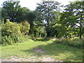
Footpath to Church Farm
Off Rectory Road near The Old Rectory
Image: © Geographer
Taken: 20 Jun 2011
0.04 miles
2
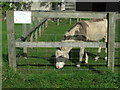
Horse thieves beware
Sign seen on paddock fencing staying 'Horse thieves beware' I think it should say 'horse thieves beware this is a donkey' seen near Kettleburgh Suffolk.
Image: © Keith Evans
Taken: 30 Sep 2007
0.05 miles
3
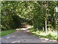
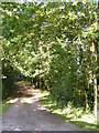
Bridleway to Lampard Brook
Off Rectory Road
Kettleburgh Bridleway no.10 leading to Framlingham Bridleway no.86
Image: © Geographer
Taken: 20 Jun 2011
0.07 miles
4
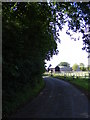
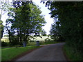
Rectory Road,Kettleburgh
Looking towards Rectory Farm and Earl Soham near the Bridleway to Lampard Brook
Road No.U2106
Image: © Geographer
Taken: 20 Jun 2011
0.07 miles
5
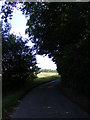
Rectory Road,Kettleburgh
Looking towards School Hill Kettleburgh near the Bridleway to Lampard Brook
Road No.U2106
Image: © Geographer
Taken: 20 Jun 2011
0.07 miles
6
Rectory Road & Bridleway to Lampardbrook
Kettleburgh Bridleway No.10 leading to Framlingham Bridleway no.86
Road No.U2106
Image: © Geographer
Taken: 20 Jun 2011
0.08 miles
7
Bridleway to Lampardbrook
Off Rectory Road
Kettleburgh Bridleway no.10 leading to Framlingham Bridleway no.86
Image: © Geographer
Taken: 20 Jun 2011
0.08 miles
8
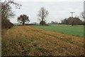
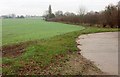
Field north of Kettleburgh
Footpath E-351 013/0 is mapped as crossing this field north of the church but, with a standing winter crop, it seems a good idea to use this generous headland around the west side.
Image: © Derek Harper
Taken: 31 Dec 2016
0.13 miles
9
Field boundary near Rectory Farm
With the entrance drive to an outbuilding in the foreground.
Image: © Derek Harper
Taken: 31 Dec 2016
0.16 miles
10
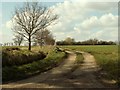
Track to Redbricks
It may be a farm, it may be just a house, the sign just says Redbricks.
Image: © Robert Edwards
Taken: 14 Mar 2007
0.19 miles