IMAGES TAKEN NEAR TO
Eyke Road, WOODBRIDGE, IP12 2PW
Introduction
This page details the photographs taken nearby to Eyke Road, IP12 2PW by members of the Geograph project.
The Geograph project started in 2005 with the aim of publishing, organising and preserving representative images for every square kilometre of Great Britain, Ireland and the Isle of Man.

There are currently over 7.5m images from over14,400 individuals and you can help contribute to the project by visiting https://www.geograph.org.uk
Image Map
Images are licensed for reuse under creativecommons.org/licenses/by-sa/2.0
Notes
- Clicking on the map will re-center to the selected point.
- The higher the marker number, the further away the image location is from the centre of the postcode.
Image Listing (96 Images Found)
Images are licensed for reuse under creativecommons.org/licenses/by-sa/2.0
Image
Details
Distance
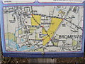
1
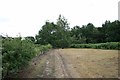
Bromeswell Common
Bromeswell has a green (straddling Common Lane) and a common (here, south-east of Image).
Image: © Hugh Craddock
Taken: 23 Jul 2010
0.06 miles
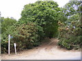
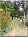
2
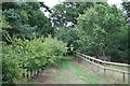
Restricted byway off Church Lane
This restricted byway links two parcels of open land, one near the church, and one larger one near Eyke Road. Just here, where it connects the two parcels, the byway has recently been fenced and hedged in.
Image: © Hugh Craddock
Taken: 23 Jul 2010
0.07 miles
3
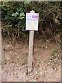
Open Access Land Map
On the A1152 Eyke Road near the Restricted Byway to Church Lane
Image: © Geographer
Taken: 26 May 2011
0.09 miles
4
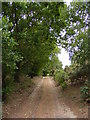
Restricted Byway to ChurchLane
Off the A1152 Eyke Road
Image: © Geographer
Taken: 26 May 2011
0.09 miles
5
Restricted Byway to ChurchLane
Off the A1152 Eyke Road
Image: © Geographer
Taken: 26 May 2011
0.09 miles
6

Restricted Byway to ChurchLane
Off the A1152 Eyke Road
Image: © Geographer
Taken: 26 May 2011
0.09 miles
7
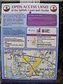
Open Access Land Map
(Close up)
On the A1152 Eyke Road near the Restricted Byway to Church Lane
Image: © Geographer
Taken: 26 May 2011
0.09 miles
8
Open Access Land Map
(Very close up)
On the A1152 Eyke Road near the Restricted Byway to Church Lane
Image: © Geographer
Taken: 26 May 2011
0.09 miles
9
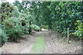
Restricted byway on Bromeswell Common
Restricted byway on Bromeswell Common, at the junction with a public footpath about 80m short of the Eyke Road (visible at the end of the byway).
Image: © Hugh Craddock
Taken: 23 Jul 2010
0.09 miles
10
Restricted Byway to B1084 Orford Road
Off the A1152 Eyke Road
Image: © Geographer
Taken: 26 May 2011
0.10 miles