IMAGES TAKEN NEAR TO
Baron Gardens, ILFORD, IG6 1PB
Introduction
This page details the photographs taken nearby to Baron Gardens, IG6 1PB by members of the Geograph project.
The Geograph project started in 2005 with the aim of publishing, organising and preserving representative images for every square kilometre of Great Britain, Ireland and the Isle of Man.

There are currently over 7.5m images from over14,400 individuals and you can help contribute to the project by visiting https://www.geograph.org.uk
Image Map
Images are licensed for reuse under creativecommons.org/licenses/by-sa/2.0
Notes
- Clicking on the map will re-center to the selected point.
- The higher the marker number, the further away the image location is from the centre of the postcode.
Image Listing (79 Images Found)
Images are licensed for reuse under creativecommons.org/licenses/by-sa/2.0
Image
Details
Distance
1
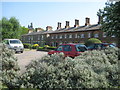
Barkingside: Pert Cottages
Two separate terraced blocks make up these former artisans' cottages, which were built in 1860 on the north side of Tanners Lane when Barking Side, as it was then known, was just a rural community. Several of these are Grade II Listed Buildings. Although contemporary with each other the two blocks are completely different with the tall angled chimneys of the block on the right giving a much older Tudor appearance.
The old Ordnance Survey map of 1864 shows the cottages and also some other similar structures immediately to the west along Tanners Lane and shown as Vaughan and Clifton Cottages. Of these not a trace can be seen today. The old map also shows how the front gardens of Pert Cottages stretched right to left in the photograph across the present day Sandringham Gardens, which was only built during the inter-war residential development of the area.
Image: © Nigel Cox
Taken: 25 Apr 2011
0.07 miles
3
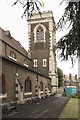
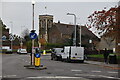
Church on Tanners Lane, viewed from Carlton Drive
This is the view that greets you as you leave the access road to Barkingside tube station. The church is on Tanners Lane just before its name changes to Horns Road and is viewed from the junction of Carlton Drive, Station Road, Crown Road and Carlton Court, looking north-east.
Image: © Robert Lamb
Taken: 1 Oct 2009
0.07 miles
4
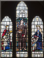
Children's Church, Barkingside - Stained glass window
Image: © John Salmon
Taken: 28 Jun 2017
0.08 miles
6
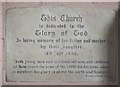
Children's Church, Barkingside - Foundation stone
Image: © John Salmon
Taken: 28 Jun 2017
0.08 miles
7
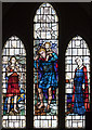
Children's Church, Barkingside - Stained glass window
Image: © John Salmon
Taken: 28 Jun 2017
0.08 miles
8
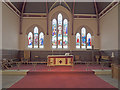
Children's Church, Barkingside - Chancel
Image: © John Salmon
Taken: 28 Jun 2017
0.08 miles
9
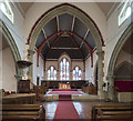
Children's Church, Barkingside - East end
Image: © John Salmon
Taken: 28 Jun 2017
0.08 miles