IMAGES TAKEN NEAR TO
Lindale Close, ILFORD, IG4 5FB
Introduction
This page details the photographs taken nearby to Lindale Close, IG4 5FB by members of the Geograph project.
The Geograph project started in 2005 with the aim of publishing, organising and preserving representative images for every square kilometre of Great Britain, Ireland and the Isle of Man.

There are currently over 7.5m images from over14,400 individuals and you can help contribute to the project by visiting https://www.geograph.org.uk
Image Map (Loading...)


Getting Data...Please wait
Leaflet Map data © OpenStreetMap
Images are licensed for reuse under creativecommons.org/licenses/by-sa/2.0
Notes
- Clicking on the map will re-center to the selected point.
- The higher the marker number, the further away the image location is from the centre of the postcode.
Image Listing (13 Images Found)
Images are licensed for reuse under creativecommons.org/licenses/by-sa/2.0
Image
Details
Distance
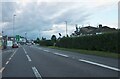
1
Beehive Lane, near Gants Hill
Evening rush hour traffic on Beehive Lane, photographed on a dull and wet May evening.
Image: © Malc McDonald
Taken: 18 May 2017
0.12 miles
2
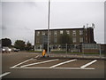
Roundabout on Woodford Avenue, Gants Hill
Image: © David Howard
Taken: 3 Sep 2017
0.13 miles
3
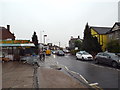
Spurway Parade, near Gants Hill
Spurway Parade is a parade of shops on the A1400 Woodford Avenue in north east London. This image was taken on a dull and wet May evening.
Image: © Malc McDonald
Taken: 18 May 2017
0.14 miles
4
Roundabout on Woodford Avenue, Clayhall
Image: © David Howard
Taken: 31 Jan 2012
0.15 miles
6
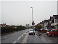
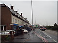
Woodford Avenue, near Gants Hill
The A1400 Woodford Avenue in north east London, looking towards Gants Hill. The road is a dual carriageway, the opposite carriageway is screened by a hedge along the central reservation.
Image: © Malc McDonald
Taken: 18 May 2017
0.16 miles
7

A1400 Woodford Avenue near Redbridge
The A1400 Woodford Avenue, photographed on a dull and wet May evening.
The road is a dual carriageway. A hedge along the central reservation hides traffic heading in the opposite direction.
Image: © Malc McDonald
Taken: 18 May 2017
0.16 miles
8
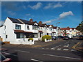
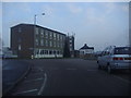
Windermere Gardens, Redbridge
Windermere Gardens is a residential street in Redbridge, in the suburbs of North East London.
Image: © Malc McDonald
Taken: 23 May 2017
0.18 miles
9
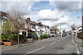
Redbridge Lane East
A neat residential street very much like those all around.
Image: © Des Blenkinsopp
Taken: 2 Apr 2024
0.19 miles
10
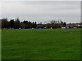
View of Canary Wharf from Clayhall Park
Looking south-southwest.
Image: © Robert Lamb
Taken: 21 Feb 2021
0.20 miles