IMAGES TAKEN NEAR TO
Abbotsford Road, ILFORD, IG3 9QX
Introduction
This page details the photographs taken nearby to Abbotsford Road, IG3 9QX by members of the Geograph project.
The Geograph project started in 2005 with the aim of publishing, organising and preserving representative images for every square kilometre of Great Britain, Ireland and the Isle of Man.

There are currently over 7.5m images from over14,400 individuals and you can help contribute to the project by visiting https://www.geograph.org.uk
Image Map (Loading...)


Getting Data...Please wait
Leaflet Map data © OpenStreetMap
Images are licensed for reuse under creativecommons.org/licenses/by-sa/2.0
Notes
- Clicking on the map will re-center to the selected point.
- The higher the marker number, the further away the image location is from the centre of the postcode.
Image Listing (41 Images Found)
Images are licensed for reuse under creativecommons.org/licenses/by-sa/2.0
Image
Details
Distance
1
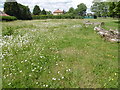
Wildflower area in Goodmayes Park
Goodmayes Park was laid out in 1901 to provide a green 'lung' for the new Mayfield Estate, built by developer A Cameron Corbett, who donated land for the park to the Urban District Council. The area grew up following the arrival of the railway in 1901 and is named after Goodmayes Farm, which once stood on what is now the park. The park was opened to the public in 1905.
Goodmayes Park is divided by Mayesbrook Road into two compartments, that in the north having a lake formed by damming the Mayes Brook. The lake is divided by a footbridge. This wildflower area is just west of the southern part of the lake.
A fuller description of the park can be seen at http://www.londongardensonline.org.uk/gardens-online-record.asp?ID=RED015
Image: © Marathon
Taken: 15 Jun 2016
0.08 miles
2
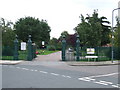
Goodmayes Park entrance
Entrance to Goodmayes Park on Abbotsford Road at the junction with Aberdour Road.
Image: © Malc McDonald
Taken: 2 Oct 2010
0.08 miles

4
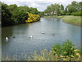
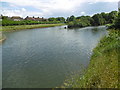
The lake in Goodmayes Park
Goodmayes Park was laid out in 1901 to provide a green 'lung' for the new Mayfield Estate, built by developer A Cameron Corbett, who donated land for the park to the Urban District Council. The area grew up following the arrival of the railway in 1901 and is named after Goodmayes Farm, which once stood on what is now the park. The park was opened to the public in 1905.
Goodmayes Park is divided by Mayesbrook Road into two compartments, that in the north having a lake formed by damming the Mayes Brook. The lake is divided by a footbridge. This is the view from the southern end of the lake. On the right is an island where birds nest.
A fuller description of the park can be seen at http://www.londongardensonline.org.uk/gardens-online-record.asp?ID=RED015
Image: © Marathon
Taken: 15 Jun 2016
0.11 miles
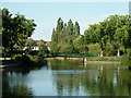
5
The lake in Goodmayes Park
Goodmayes Park was laid out in 1901 to provide a green 'lung' for the new Mayfield Estate, built by developer A Cameron Corbett, who donated land for the park to the Urban District Council. The area grew up following the arrival of the railway in 1901 and is named after Goodmayes Farm, which once stood on what is now the park. The park was opened to the public in 1905.
Goodmayes Park is divided by Mayesbrook Road into two compartments, that in the north having a lake formed by damming the Mayes Brook. The lake is divided by a footbridge. This is the view from the footbridge looking to the southern part of the lake.
A fuller description of the park can be seen at http://www.londongardensonline.org.uk/gardens-online-record.asp?ID=RED015
Image: © Marathon
Taken: 15 Jun 2016
0.12 miles
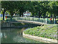
6
Lake in Goodmayes Park
This end has an island, just showing on the right. The part beyond the bridge is bigger but narrower.
Image: © Robin Webster
Taken: 25 Jun 2011
0.13 miles
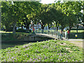
9
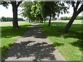
Avenue of trees in Goodmayes Park
Goodmayes Park was laid out in 1901 to provide a green 'lung' for the new Mayfield Estate, built by developer A Cameron Corbett, who donated land for the park to the Urban District Council. The area grew up following the arrival of the railway in 1901 and is named after Goodmayes Farm, which once stood on what is now the park. The park was opened to the public in 1905.
Goodmayes Park is divided by Mayesbrook Road into two compartments, that in the north having a lake formed by damming the Mayes Brook. The lake is divided by a footbridge. This is the view as the park is entered from Holden Close.
A fuller description of the park can be seen at http://www.londongardensonline.org.uk/gardens-online-record.asp?ID=RED015
Image: © Marathon
Taken: 15 Jun 2016
0.13 miles