IMAGES TAKEN NEAR TO
Egerton Gardens, ILFORD, IG3 9HR
Introduction
This page details the photographs taken nearby to Egerton Gardens, IG3 9HR by members of the Geograph project.
The Geograph project started in 2005 with the aim of publishing, organising and preserving representative images for every square kilometre of Great Britain, Ireland and the Isle of Man.

There are currently over 7.5m images from over14,400 individuals and you can help contribute to the project by visiting https://www.geograph.org.uk
Image Map
Images are licensed for reuse under creativecommons.org/licenses/by-sa/2.0
Notes
- Clicking on the map will re-center to the selected point.
- The higher the marker number, the further away the image location is from the centre of the postcode.
Image Listing (5 Images Found)
Images are licensed for reuse under creativecommons.org/licenses/by-sa/2.0
Image
Details
Distance
1
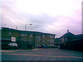
Entrance to Oaklea Lodge and Mayesbrook Primary School
Oaklea Lodge provides residential care for the elderly. This road is also used for vehicular access to Mayesbrook Primary School, the main building of which can be seen in the background. View taken looking west-southwest in the direction of Ilford.
Image: © Robert Lamb
Taken: 15 Nov 2008
0.17 miles
2
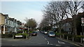
View of Morrab Gardens from Water Lane
Morrab Gardens is quite a stark contrast to surrounding roads as it is part of the Mayfield Conservation Area. Looking north-northeast.
Image: © Robert Lamb
Taken: 28 Mar 2014
0.17 miles
3
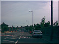
New modern lamp posts on Goodmayes Lane
In mid-2008, these new modern lamp posts were installed on Goodmayes Lane as the old 1980s lamp posts with Philips SGS203 lanterns were getting a little worse for wear. The new lanterns are made in Belgium by a company called Urbis and are called Furyos. I took this shot through the rear screen of the car as it is a nice, sweeping curve and gives the perfect opportunity to really appreciate these installations. View taken near the junction of Goodmayes Lane and Longbridge Road, looking north-northwest.
Image: © Robert Lamb
Taken: 14 Jun 2008
0.20 miles
4
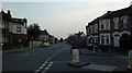
View down Water Lane from outside South Park Chapel
Looking south-southwest. South Park Primary School can be seen to the right.
Image: © Robert Lamb
Taken: 28 Mar 2014
0.23 miles
5
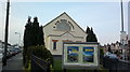
View of South Park Chapel from Ripley Road
Looking north-northeast.
Image: © Robert Lamb
Taken: 28 Mar 2014
0.25 miles