IMAGES TAKEN NEAR TO
High Road, ILFORD, IG3 8BS
Introduction
This page details the photographs taken nearby to High Road, IG3 8BS by members of the Geograph project.
The Geograph project started in 2005 with the aim of publishing, organising and preserving representative images for every square kilometre of Great Britain, Ireland and the Isle of Man.

There are currently over 7.5m images from over14,400 individuals and you can help contribute to the project by visiting https://www.geograph.org.uk
Image Map (Loading...)


Getting Data...Please wait
Leaflet Map data © OpenStreetMap
Images are licensed for reuse under creativecommons.org/licenses/by-sa/2.0
Notes
- Clicking on the map will re-center to the selected point.
- The higher the marker number, the further away the image location is from the centre of the postcode.
Image Listing (58 Images Found)
Images are licensed for reuse under creativecommons.org/licenses/by-sa/2.0
Image
Details
Distance
1
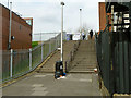
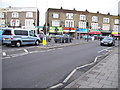
Flight of steps, Seven Kings
Connecting Salisbury Road with the High Road, these are not because of any steep natural relief, but because the High Road has been built up to bridge the railway.
Image: © Robin Webster
Taken: 2 Apr 2011
0.01 miles
3
Seven Kings Railway Station
On the Great Eastern Main Line, 8 miles 46 chains down the line from London Liverpool Street.
Image: © JThomas
Taken: 22 Aug 2022
0.02 miles
4
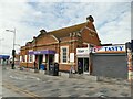
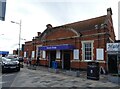
Seven Kings: station building
The station is entered from the bridge taking High Road across the railway. The style of this building is consistent with the 1899 opening date of the station, so I presume it is the original.
Image: © Stephen Craven
Taken: 31 May 2022
0.02 miles
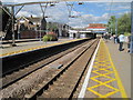
6
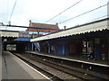
Seven Kings station
The line through here was opened on 20th June 1839 by the Eastern Counties Railway, as the Mile End (temporary terminus) to Romford section of what was to become the Great Eastern Main Line. The London terminus was moved in July 1840 to Shoreditch (later renamed Bishopsgate), and at the eastern end the line was extended out to Brentwood in the same year. Colchester was reached by 1843. Liverpool Street opened in stages from February 1874. The line was quadrupled to Ilford in 1895 and in 1899 out to Seven Kings, at which stage Seven Kings station opened on 1st March 1899. In 1902 the quadruple track was extended from Seven Kings to Romford.
In this photograph the original lines, now the slow lines are to the left while the fast lines dating from 1902 are to the right beyond the railings. The next station in this direction is Goodmayes.
Image: © Marathon
Taken: 4 May 2016
0.03 miles
8
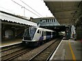
Seven Kings: loacl train to Shenfield
There is a regular stopping service from London to Shenfield. Here, unit 345039 forms the rear of a down (eastbound) train leaving Seven Kings station at 09.48. Note the signal at the end of platform 3 equipped with lights indicating a move for down trains from the up slow line to the fast lines beyond the station. I imagine that such a move is rarely needed.
Image: © Stephen Craven
Taken: 31 May 2022
0.03 miles
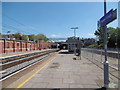
9
Seven Kings railway station, Greater London, 2012
Opened in 1899 by the Great Eastern Railway on its line from London Liverpool Street to Shenfield.
View east towards Goodmayes and Shenfield from the southern-most platform. See Image for a 2020 view from the northern-most platform.
Image: © Nigel Thompson
Taken: 24 Jun 2012
0.04 miles