IMAGES TAKEN NEAR TO
Cheviot Way, ILFORD, IG2 7PZ
Introduction
This page details the photographs taken nearby to Cheviot Way, IG2 7PZ by members of the Geograph project.
The Geograph project started in 2005 with the aim of publishing, organising and preserving representative images for every square kilometre of Great Britain, Ireland and the Isle of Man.

There are currently over 7.5m images from over14,400 individuals and you can help contribute to the project by visiting https://www.geograph.org.uk
Image Map
Images are licensed for reuse under creativecommons.org/licenses/by-sa/2.0
Notes
- Clicking on the map will re-center to the selected point.
- The higher the marker number, the further away the image location is from the centre of the postcode.
Image Listing (26 Images Found)
Images are licensed for reuse under creativecommons.org/licenses/by-sa/2.0
Image
Details
Distance
6
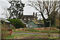
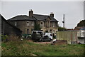
Aldborough House Farm
The building being reroofed appears to be the grade II listed barn of about 1730, 'originally the chapel attached to Aldborough Hall'.
Image: © Robin Webster
Taken: 9 Apr 2011
0.11 miles
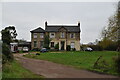
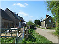
8
Aldborough Hatch Farm
Clearly once the principal house of the farm, in the 1960s it was mapped as "flats", and that may still be the case.
Image: © Robin Webster
Taken: 9 Apr 2011
0.14 miles
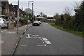
10
Footpath 97 sign at the eastern end
Footpath 97 runs from the corner of Oaks Lane over the London Underground line and on to Perkins Road.
Image: © Phil Gaskin
Taken: 30 May 2017
0.16 miles