IMAGES TAKEN NEAR TO
Durban Road, ILFORD, IG2 7AQ
Introduction
This page details the photographs taken nearby to Durban Road, IG2 7AQ by members of the Geograph project.
The Geograph project started in 2005 with the aim of publishing, organising and preserving representative images for every square kilometre of Great Britain, Ireland and the Isle of Man.

There are currently over 7.5m images from over14,400 individuals and you can help contribute to the project by visiting https://www.geograph.org.uk
Image Map
Images are licensed for reuse under creativecommons.org/licenses/by-sa/2.0
Notes
- Clicking on the map will re-center to the selected point.
- The higher the marker number, the further away the image location is from the centre of the postcode.
Image Listing (36 Images Found)
Images are licensed for reuse under creativecommons.org/licenses/by-sa/2.0
Image
Details
Distance
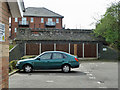
1
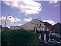
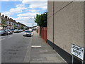
Old 1930s style lamp-post in a front garden on Cameron Road
This beautiful 1930s style lamp-post can be found in the front garden of the corner house at the junction of Cameron Road and Elgin Road. I have posted on to a streetlight enthusiast's website to try to get it identified! View taken from Cameron Road, near the bottom edge of the square, looking south-east in the direction of Seven Kings Station.
Image: © Robert Lamb
Taken: 15 Aug 2008
0.12 miles
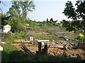
3
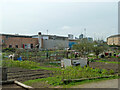
Vicarage Lane Allotments South
Vicarage Lane Allotments North is on the other side of the road but further west.
Image: © Robin Webster
Taken: 2 Apr 2011
0.17 miles
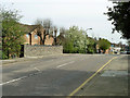
4
Ilford: Former Benton Road railway bridge
The bridge on the summit used to carry Benton Road over the former Great Eastern Railway's Woodford and Ilford branch. However the railway has long since been demolished and only this bridge and two other similar ones in the area remain as reminders.
Image: © Nigel Cox
Taken: 25 Apr 2011
0.17 miles
5
Ilford: Former Great Eastern Railway's Woodford and Ilford Branch
The Great Eastern Railway built their Woodford and Ilford Branch through here and opened it in 1903. With the taking over of most of the branch by London Underground after the Second World War and with the opening of the new Central Line underground route between Newbury Park and Leytonstone in 1947, passenger services were withdrawn from this section. Freight services continued to 1956, and the track was lifted shortly afterwards.
Today this section, with the rear gardens of the houses in Charter Avenue to the left, has been converted to allotments. This is the view from Image
Image: © Nigel Cox
Taken: 25 Apr 2011
0.17 miles
6
Old railway bridge, Fairlop Loop
The Fairlop Loop left the Great Eastern main line roughly in the middle of what is now Ilford Depot, and ran north to loop around to join the Loughton - Epping - Ongar line. The first mile was abandoned when the rest of the line became part of the Central tube line - the tube coming to the surface south of Newbury Park station. There are three road over-bridges on the abandoned part, all seemingly in similar condition to this one - structurally intact but partly buried. This carries Vicarage Lane, the others, Benton Road and Wards Road. The building on the far side of the bridge is on the site of the north junction of the triangular connection to the main line and is part of the residential redevelopment of the site of the former Plessey Company, which occupied the land on the south side of Vicarage Lane from this bridge westwards to the junction with Ley Street and latterly used the junction site as a car park.
Image: © Robin Webster
Taken: 2 Apr 2011
0.18 miles
7
Bridge over former Fairlop Loop line
A parapet of the apparently intact but partly buried bridge taking Vicarage Lane over the course of the GER Fairlop loop line. The southern end of this was abandoned when the rest of the line was connected to an extension of the Central Line and became part of it.
Image: © Robin Webster
Taken: 2 Apr 2011
0.19 miles
8
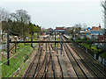
Great Eastern line approaching Seven Kings station
The Electric lines are on the left, the Main lines (electrified later) on the right. The crossover enables up trains to enter Ilford Depot, just behind the viewpoint.
Image: © Robin Webster
Taken: 2 Apr 2011
0.20 miles
10
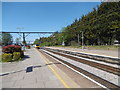
Seven Kings station
The line through here was opened on 20th June 1839 by the Eastern Counties Railway, as the Mile End (temporary terminus) to Romford section of what was to become the Great Eastern Main Line. The London terminus was moved in July 1840 to Shoreditch (later renamed Bishopsgate), and at the eastern end the line was extended out to Brentwood in the same year. Colchester was reached by 1843. Liverpool Street opened in stages from February 1874. The line was quadrupled to Ilford in 1895 and in 1899 out to Seven Kings, at which stage Seven Kings station opened on 1st March 1899. In 1902 the quadruple track was extended from Seven Kings to Romford.
In this photograph the original lines, now the slow lines are to the right while the fast lines dating from 1902 are out of sight to the left beyond railings. A TfL train bound for Liverpool Street is just leaving. The next station in this direction is Ilford.
Image: © Marathon
Taken: 4 May 2016
0.21 miles