IMAGES TAKEN NEAR TO
Balfour Road, ILFORD, IG1 4JB
Introduction
This page details the photographs taken nearby to Balfour Road, IG1 4JB by members of the Geograph project.
The Geograph project started in 2005 with the aim of publishing, organising and preserving representative images for every square kilometre of Great Britain, Ireland and the Isle of Man.

There are currently over 7.5m images from over14,400 individuals and you can help contribute to the project by visiting https://www.geograph.org.uk
Image Map (Loading...)


Getting Data...Please wait
Leaflet Map data © OpenStreetMap
Images are licensed for reuse under creativecommons.org/licenses/by-sa/2.0
Notes
- Clicking on the map will re-center to the selected point.
- The higher the marker number, the further away the image location is from the centre of the postcode.
Image Listing (43 Images Found)
Images are licensed for reuse under creativecommons.org/licenses/by-sa/2.0
Image
Details
Distance
1
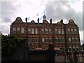
View of Christchurch Primary School's Main building from Wellesley Road
This is a view of the 110-year-old Main building of Christchurch Primary School from Wellesley Road - I was lucky enough to witness its centenary in 2000! View taken looking south-southeast.
Image: © Robert Lamb
Taken: 2 Aug 2010
0.10 miles
2
View of Christchurch Primary School's Minaret from Wellesley Road
The distinctive black minaret of Christchurch Primary School can be seen from a handful of streets on the Commonwealth Estate (so named as all the streets are named after cities from the Commonwealth countries). I attended Christchurch from 1994 to 2002, and so this was the view that greeted me on my walk up to the school every morning for 8 years - it hasn't changed one bit! I was also lucky enough to be there at the time when it celebrated its centenary in 2000. This is the view from Wellesley Road, looking southwest towards Ilford town centre.
Image: © Robert Lamb
Taken: 2 Aug 2010
0.10 miles
3
A 110-year-old photograph!
Everything in this photograph (save for the modern junction box at the bottom of the image) is 110 years old. If this were black and white, I'd forgive you for thinking this was taken in the 1900s! This is the rear of the Dane building and the side of the site manager's house. View taken looking south.
Image: © Robert Lamb
Taken: 2 Aug 2010
0.11 miles
4
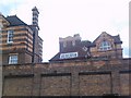
View of the Dane building and the site manager's house from Wellesley Road
The Dane building now houses the Teacher's Centre, but in the early 20th century it was Dane Primary School - a separate school from Christchurch, meaning that were two separate schools on one premises! My father and grandfather were educated here, my grandfather in the 1930s and 1940s and my father in the 1950s and 1960s. The building in the foreground on the right is the site manager's house. View taken looking south from Wellesley Road.
Image: © Robert Lamb
Taken: 2 Aug 2010
0.12 miles
6
The site manager's house, viewed from Wellesley Road
Here's a closer, unobstructed view of the site manager's house on Wellesley Road, looking south.
Image: © Robert Lamb
Taken: 2 Aug 2010
0.12 miles
7
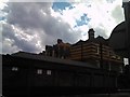
The Dane building from Melbourne Road, Ilford
The sign round the corner at the Balfour Road entrance reads Christchurch Children's Centre, as opposed to Christchurch Primary School, the other large building on the site Image
Image: © Chris Brown
Taken: 28 Aug 2018
0.13 miles
8
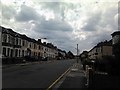
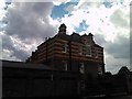
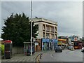
View of Raphael House from Ley Street
Looking south-southwest. On the left is the Bell pub, yet another pub gone at the mercy of the economic climate and 2007 smoking ban.
Image: © Robert Lamb
Taken: 6 Feb 2014
0.13 miles
9
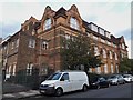
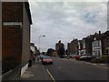
The former Bell Inn on Ley Street
The building bears a date of 1898 but it had closed by 2014 Image The ground floor is now occupied by a catering business.
Image: © Stephen Craven
Taken: 30 May 2022
0.16 miles
10
View of Christchurch Primary School's Minaret from Wellesley Road #2
Taken looking north-northeast back toward where Image was taken.
Image: © Robert Lamb
Taken: 2 Aug 2010
0.16 miles