IMAGES TAKEN NEAR TO
Hainault Street, ILFORD, IG1 4GZ
Introduction
This page details the photographs taken nearby to Hainault Street, IG1 4GZ by members of the Geograph project.
The Geograph project started in 2005 with the aim of publishing, organising and preserving representative images for every square kilometre of Great Britain, Ireland and the Isle of Man.

There are currently over 7.5m images from over14,400 individuals and you can help contribute to the project by visiting https://www.geograph.org.uk
Image Map
Images are licensed for reuse under creativecommons.org/licenses/by-sa/2.0
Notes
- Clicking on the map will re-center to the selected point.
- The higher the marker number, the further away the image location is from the centre of the postcode.
Image Listing (117 Images Found)
Images are licensed for reuse under creativecommons.org/licenses/by-sa/2.0
Image
Details
Distance
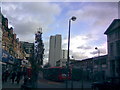
1

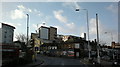
View of the Ilford skyline from Ley Street
From left to right, Raphael House, Lynton House, Centreview Apartments, the Ilfomation office block and Spectrum Towers. The long white building in front of these is the multi-storey car park for the bus station and peeking above these are the old Harrison and Gibson department store building and Pioneer Point. Looking south-southwest.
Image: © Robert Lamb
Taken: 5 Feb 2014
0.02 miles
2
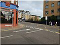
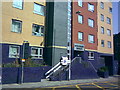
Havelock Street Junction with Hainault Street, Ilford
AS there is a nearby pub called The General Havelock, I assume the Street is named after Major General Sir Henry Havelock KCB (5 April 1795 – 24 November 1857), a British general who is particularly associated with India and his recapture of Cawnpore during the Indian Rebellion of 1857 (First War of Independence, Sepoy Mutiny).
Image: © Richard Rogerson
Taken: 27 Oct 2021
0.02 miles
3
View of Vector Point and Pioneer Point from Ley Street
Looking south-southwest.
Image: © Robert Lamb
Taken: 5 Feb 2014
0.02 miles
4
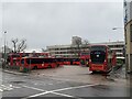
Ilford Bus Station/Depot
Ilford Bus Station/Depot
Multi storey Car Park in the background.
Image: © Gita Patel
Taken: 8 Jan 2022
0.03 miles
5
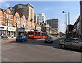
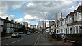
High Road, Ilford IG1 looking east beyond pedestrianised area
Image: © John Salmon
Taken: 9 Apr 2007
0.03 miles
6
Spectrum Towers, Hainault Street
This is the first of three tower blocks (constructed in 2006) which have been created in Ilford town centre. It's called Spectrum Towers, and is located on the left side of Hainault Street immediately after the railway bridge. View taken looking north-northeast from Hainault Street at the junction of Station Road.
Image: © Robert Lamb
Taken: 30 Aug 2008
0.03 miles
7
View of the Ilford skyline from Richmond Road #2
Taken from further along the road, at the junction of Albert Road, looking north-northwest.
Image: © Robert Lamb
Taken: 4 Feb 2014
0.04 miles
8
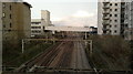
View of the Greater Anglia railway towards Shenfield from Hainault Street
Looking north-northeast. Griggs Approach crosses the railway on the concrete flyover in the background.
Image: © Robert Lamb
Taken: 25 Feb 2014
0.04 miles
9
View of Centreview Apartments and Pioneer Point from Ley Street
Looking south-southwest.
Image: © Robert Lamb
Taken: 6 Feb 2014
0.04 miles
10
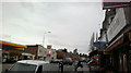
Tower block complete
The tower block shown in Image has recently been completed, and now looks like this! A complete eyesore, isn't it? I think the nightclub which once stood there looked much better! View taken looking east along the High Street just where the pedestrianised section begins.
Image: © Robert Lamb
Taken: 27 Nov 2009
0.05 miles