IMAGES TAKEN NEAR TO
Vicarage Lane, ILFORD, IG1 4AG
Introduction
This page details the photographs taken nearby to Vicarage Lane, IG1 4AG by members of the Geograph project.
The Geograph project started in 2005 with the aim of publishing, organising and preserving representative images for every square kilometre of Great Britain, Ireland and the Isle of Man.

There are currently over 7.5m images from over14,400 individuals and you can help contribute to the project by visiting https://www.geograph.org.uk
Image Map
Images are licensed for reuse under creativecommons.org/licenses/by-sa/2.0
Notes
- Clicking on the map will re-center to the selected point.
- The higher the marker number, the further away the image location is from the centre of the postcode.
Image Listing (40 Images Found)
Images are licensed for reuse under creativecommons.org/licenses/by-sa/2.0
Image
Details
Distance
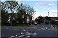
1
Weird trees on Kings Gardens
Near the junction with Ley Street. I've never seen anything like this before. I have no idea what kind of tree they are.
Image: © Antony Dixon
Taken: 23 Feb 2012
0.08 miles
3
All Nations Church, Ley Street
A congregation of the International Presbyterian Church.
Image: © Stephen Craven
Taken: 30 May 2022
0.09 miles
5
Jaffe Road at the junction of Ley Street
Image: © David Howard
Taken: 9 May 2021
0.12 miles
6
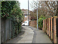
Path towards Jaffe Road, Ilford
From High Road via a lengthy bridge over the railway.
Image: © Robin Webster
Taken: 2 Apr 2011
0.12 miles
7
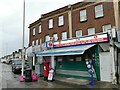
Ley Street Post Office
The GR postbox outside suggests this has been a post office since before 1937, but like most such urban facilities it now offers a wide range of services from food sales to money transfer and lottery tickets.
Image: © Stephen Craven
Taken: 30 May 2022
0.12 miles
8
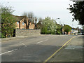
Bridge over former Fairlop Loop line
A parapet of the apparently intact but partly buried bridge taking Vicarage Lane over the course of the GER Fairlop loop line. The southern end of this was abandoned when the rest of the line was connected to an extension of the Central Line and became part of it.
Image: © Robin Webster
Taken: 2 Apr 2011
0.13 miles
9
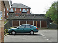
Old railway bridge, Fairlop Loop
The Fairlop Loop left the Great Eastern main line roughly in the middle of what is now Ilford Depot, and ran north to loop around to join the Loughton - Epping - Ongar line. The first mile was abandoned when the rest of the line became part of the Central tube line - the tube coming to the surface south of Newbury Park station. There are three road over-bridges on the abandoned part, all seemingly in similar condition to this one - structurally intact but partly buried. This carries Vicarage Lane, the others, Benton Road and Wards Road. The building on the far side of the bridge is on the site of the north junction of the triangular connection to the main line and is part of the residential redevelopment of the site of the former Plessey Company, which occupied the land on the south side of Vicarage Lane from this bridge westwards to the junction with Ley Street and latterly used the junction site as a car park.
Image: © Robin Webster
Taken: 2 Apr 2011
0.14 miles
10
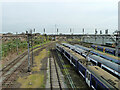
Sidings, Ilford Depot, 2011
A varied selection of rolling stock. Classes 321, 315, 379 and possibly others.
Image: © Robin Webster
Taken: 2 Apr 2011
0.14 miles