IMAGES TAKEN NEAR TO
Ilford Lane, ILFORD, IG1 2JY
Introduction
This page details the photographs taken nearby to Ilford Lane, IG1 2JY by members of the Geograph project.
The Geograph project started in 2005 with the aim of publishing, organising and preserving representative images for every square kilometre of Great Britain, Ireland and the Isle of Man.

There are currently over 7.5m images from over14,400 individuals and you can help contribute to the project by visiting https://www.geograph.org.uk
Image Map (Loading...)


Getting Data...Please wait
Leaflet Map data © OpenStreetMap
Images are licensed for reuse under creativecommons.org/licenses/by-sa/2.0
Notes
- Clicking on the map will re-center to the selected point.
- The higher the marker number, the further away the image location is from the centre of the postcode.
Image Listing (130 Images Found)
Images are licensed for reuse under creativecommons.org/licenses/by-sa/2.0
Image
Details
Distance
1
View of Ilford Methodist Church from Britannia Road
Looking north-northeast.
Image: © Robert Lamb
Taken: 24 Feb 2014
0.03 miles
4
Roundabout at junction of Winston Way and Ilford Lane
This is the only other roundabout on Winston Way aside from the one at the junction of Griggs Approach, Winston Way and Riches Road. I took this image from Winston Way looking over to Ilford Lane, the road to Barking (south-southeast). Winston Way carries on after the roundabout past the new Cineworld cinema out of shot to the left.
Image: © Robert Lamb
Taken: 7 Aug 2008
0.05 miles
5
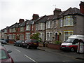
Britannia Road, Ilford
The houses are the standard type for the area.
Image: © Danny P Robinson
Taken: 13 May 2007
0.05 miles
6

Recycling Site, Audrey Road, Ilford
This kerbside mini recycling site is on Ilford Lane, at the end of Audrey Road.
Image: © Danny P Robinson
Taken: 13 May 2007
0.05 miles
7

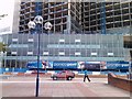
Pioneer Point Tower
What was Pioneer Market is now Pioneer Point Tower. It is comprised of social care and private apartments, Hotel, Gym, Global Foods Restaurant and Driving Theory Test centre.
The roundabout is known as Winston Way Roundabout with an underpass.
Image: © Gita Patel
Taken: 16 Dec 2021
0.05 miles
8
Pioneer Point, Winston Way, Ilford
Pioneer Point is yet another new block of flats currently being constructed in Ilford on the site of the Pioneer covered market. It is the same block of flats which can be seen from Image View taken looking north-northeast from the benches outside Sainsbury's.
Image: © Robert Lamb
Taken: 15 Aug 2010
0.08 miles
10

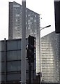
Pioneer Point
Currently being built on the site of the old Pioneer covered market, the development comprises two towers, one of 25 storeys and the other of 33 storeys, containing 294 apartments. At the base of the towers will be a 3 storey shopping and amenity block.
In the foreground is the bus terminus on Chapel Road. The photograph was taken from the 9th floor of Mill House on Ilford Hill
Image: © Martin Addison
Taken: 15 Nov 2010
0.10 miles