IMAGES TAKEN NEAR TO
Dahlia Gardens, ILFORD, IG1 2JU
Introduction
This page details the photographs taken nearby to Dahlia Gardens, IG1 2JU by members of the Geograph project.
The Geograph project started in 2005 with the aim of publishing, organising and preserving representative images for every square kilometre of Great Britain, Ireland and the Isle of Man.

There are currently over 7.5m images from over14,400 individuals and you can help contribute to the project by visiting https://www.geograph.org.uk
Image Map
Images are licensed for reuse under creativecommons.org/licenses/by-sa/2.0
Notes
- Clicking on the map will re-center to the selected point.
- The higher the marker number, the further away the image location is from the centre of the postcode.
Image Listing (53 Images Found)
Images are licensed for reuse under creativecommons.org/licenses/by-sa/2.0
Image
Details
Distance
1
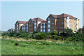
Flats, Barking
Overlooking the River Roding which is hidden below the bushes.
Image: © Robin Webster
Taken: 24 Apr 2011
0.10 miles
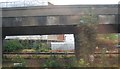
5
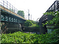
Between bridges, River Roding
The District Line bridge is on the right, the Barking - Forest Gate line on the left.
Image: © Robin Webster
Taken: 24 Apr 2011
0.15 miles
6
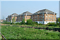
Flats, Barking
Overlooking the River Roding which is hidden below the bushes.
Image: © Robin Webster
Taken: 24 Apr 2011
0.16 miles
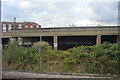
7
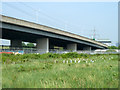
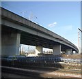
Viaduct on North Circular Road
The A406 along the Roding valley is ramping up to cross railway lines off to the left.
Image: © Robin Webster
Taken: 24 Apr 2011
0.16 miles
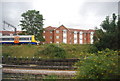
8
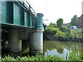
River Roding by railway bridge
The bridge carries the Fenchurch Street lines west of Barking station.
Image: © Robin Webster
Taken: 24 Apr 2011
0.16 miles
10
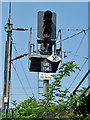
Signal UR156, East Ham
An interesting signal, with three aspects for the main up line to Fenchurch Street, below a shunt signal associated with a connection to East Ham Depot, below that a white diamond with an X and above this to the right a small light which, when required, flashes white. The diamond indicates it is not required to physically go to the signal box (there is none nearby) if detained for some time. The X denotes don't leave the cab to phone because of limited clearances - there is no other line nearby, so presumably the hazard is falling in the River Roding. When the small light flashes, phone communication with the signaller is required. Helpfully, the phone number is also given. Photographed from the west bank of the River Roding when seeing how far south it was possible to get. Except at high water (the railway bridges are very low) this is just about the limit, as the nettlebeds start getting extremely fierce.
Image: © Robin Webster
Taken: 24 Apr 2011
0.17 miles