IMAGES TAKEN NEAR TO
Ilford Hill, ILFORD, IG1 2FB
Introduction
This page details the photographs taken nearby to Ilford Hill, IG1 2FB by members of the Geograph project.
The Geograph project started in 2005 with the aim of publishing, organising and preserving representative images for every square kilometre of Great Britain, Ireland and the Isle of Man.

There are currently over 7.5m images from over14,400 individuals and you can help contribute to the project by visiting https://www.geograph.org.uk
Image Map
Images are licensed for reuse under creativecommons.org/licenses/by-sa/2.0
Notes
- Clicking on the map will re-center to the selected point.
- The higher the marker number, the further away the image location is from the centre of the postcode.
Image Listing (126 Images Found)
Images are licensed for reuse under creativecommons.org/licenses/by-sa/2.0
Image
Details
Distance
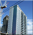
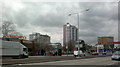
2
Tower blocks in the centre of Ilford
From Mill Road
Image: © David Howard
Taken: 6 Jun 2020
0.02 miles
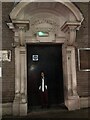
3
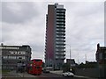
Icon Building, Ilford
London St Andrew's College on Ilford Hill.
Image: © David Anstiss
Taken: 31 Mar 2013
0.02 miles
4
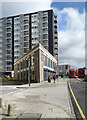
Building shapes on Ilford Hill
A bit of structure geometry near Ilford town centre.
Image: © Des Blenkinsopp
Taken: 2 Apr 2024
0.03 miles
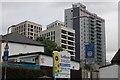
5
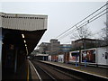
Buildings on Ilford Hill, viewed from Ilford station
Taken from Platform 2 of Ilford Station, this is a view of the buildings at the junction of Ilford Hill, Cranbrook Road and Chapel Road. Looking east-southeast.
Image: © Robert Lamb
Taken: 20 Feb 2011
0.04 miles
6

Ilford Police Station
We went to the Ilford Police Station. It is old but still in a good shape.
Image: © Lukas Saltibus
Taken: 10 Jan 2022
0.04 miles
7
Ilford Central Telephone Exchange
Connecting whole of Ilford Central with broadband and telephone!
Image: © Lukas Saltibus
Taken: 7 Dec 2021
0.04 miles
8
View of Mill House, the Icon building and Valentines House from Ilford Hill
Mill House is BT's office building, the Icon building houses London St Andrew's College and Valentines House contains several small businesses. Looking north-northwest from Winston Way.
Image: © Robert Lamb
Taken: 4 Mar 2014
0.05 miles
9
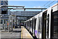
Ilford Station - the Elizabeth Line
One of the new Elizabeth Line trains about to depart eastbound for Liverpool Street. Work is not yet complete at Ilford to upgrade it and make it compatible with the new line.
Ahead is the bridge for exits to Ilford Hill (left) and York Road (right),
Image: © Trevor Harris
Taken: 27 May 2022
0.05 miles
10

Scene at Ilford station
Ilford station was opened on 20th June 1839 by the Eastern Counties Railway, along with the Mile End (temporary terminus) to Romford section of what was to become the Great Eastern Main Line. The London terminus was moved in July 1840 to Shoreditch (later renamed Bishopsgate), and at the eastern end the line was extended out to Brentwood in the same year. Colchester was reached by 1843. Liverpool Street opened in stages from February 1874. The line was quadrupled to Ilford in 1895.
On New Year's Day 1915 Ilford station was the scene of a major collision in which 10 people were killed and on 16th January 1944 nine people were killed in another collision.
The station has five platforms, two "up" (headed west toward Liverpool Street) and two "down" (towards Shenfield). The fifth platform, seen here passing under the footbridge, is a bay platform, allowing peak services into London to start at Ilford. See also http://www.geograph.org.uk/photo/4866855
Image: © Marathon
Taken: 16 Mar 2016
0.06 miles