IMAGES TAKEN NEAR TO
Juniper Road, ILFORD, IG1 2EG
Introduction
This page details the photographs taken nearby to Juniper Road, IG1 2EG by members of the Geograph project.
The Geograph project started in 2005 with the aim of publishing, organising and preserving representative images for every square kilometre of Great Britain, Ireland and the Isle of Man.

There are currently over 7.5m images from over14,400 individuals and you can help contribute to the project by visiting https://www.geograph.org.uk
Image Map (Loading...)


Getting Data...Please wait
Leaflet Map data © OpenStreetMap
Images are licensed for reuse under creativecommons.org/licenses/by-sa/2.0
Notes
- Clicking on the map will re-center to the selected point.
- The higher the marker number, the further away the image location is from the centre of the postcode.
Image Listing (95 Images Found)
Images are licensed for reuse under creativecommons.org/licenses/by-sa/2.0
Image
Details
Distance
1
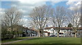
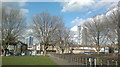
View of Mill House and the Icon Building from the park on Lowbrook Road, Ilford
Looking north-northwest.
Image: © Robert Lamb
Taken: 24 Feb 2014
0.03 miles
2
View of the Icon Building from Agnes Avenue
Looking north-northwest.
Image: © Robert Lamb
Taken: 24 Feb 2014
0.04 miles
3
View of Mill House and the Icon Building from Riverdene Road
Mill House is BT's office block, whilst the Icon building houses London St Andrew's College. Both buildings are on Ilford Hill. Looking north-northwest.
Image: © Robert Lamb
Taken: 24 Feb 2014
0.04 miles
4
View of Pioneer Point through the trees from the park on Lowbrook Road, Ilford
Looking north-northeast.
Image: © Robert Lamb
Taken: 24 Feb 2014
0.07 miles
5
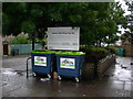
Recycling Site, Audrey Road, Ilford
This kerbside mini recycling site is on Ilford Lane, at the end of Audrey Road.
Image: © Danny P Robinson
Taken: 13 May 2007
0.08 miles
6
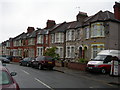
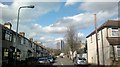
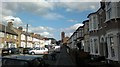
Britannia Road, Ilford
The houses are the standard type for the area.
Image: © Danny P Robinson
Taken: 13 May 2007
0.08 miles
7
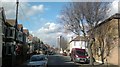
Pioneer Point Tower
What was Pioneer Market is now Pioneer Point Tower. It is comprised of social care and private apartments, Hotel, Gym, Global Foods Restaurant and Driving Theory Test centre.
The roundabout is known as Winston Way Roundabout with an underpass.
Image: © Gita Patel
Taken: 16 Dec 2021
0.08 miles
8
View of Cleveland Infant and Junior School from Cecil Road
Looking north-northeast.
Image: © Robert Lamb
Taken: 24 Feb 2014
0.09 miles
9
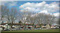
View of the Icon Building and Pioneer Point from the park on Lowbrook Road, Ilford
In the area between Kenneth Avenue and Lowbrook and Cecil Roads in Ilford is a small, unnamed park. One of the views to be had from the park is this one of the Icon Building and Pioneer Point. Looking north-northeast.
Image: © Robert Lamb
Taken: 24 Feb 2014
0.09 miles
10
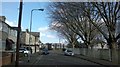
View of Ilford Methodist Church from Britannia Road
Looking north-northeast.
Image: © Robert Lamb
Taken: 24 Feb 2014
0.11 miles