IMAGES TAKEN NEAR TO
Station Parade, BARKING, IG11 8ED
Introduction
This page details the photographs taken nearby to Station Parade, IG11 8ED by members of the Geograph project.
The Geograph project started in 2005 with the aim of publishing, organising and preserving representative images for every square kilometre of Great Britain, Ireland and the Isle of Man.

There are currently over 7.5m images from over14,400 individuals and you can help contribute to the project by visiting https://www.geograph.org.uk
Image Map
Images are licensed for reuse under creativecommons.org/licenses/by-sa/2.0
Notes
- Clicking on the map will re-center to the selected point.
- The higher the marker number, the further away the image location is from the centre of the postcode.
Image Listing (186 Images Found)
Images are licensed for reuse under creativecommons.org/licenses/by-sa/2.0
Image
Details
Distance
1
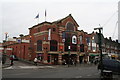
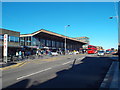
Vicarage Field shopping centre, Barking
Conveniently situated almost opposite the station, this shopping centre shows that it is perfectly possible to provide an attractive and tasteful building for such an enterprise.
Image: © Dr Neil Clifton
Taken: 28 Nov 2007
0.04 miles
4
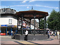
Bandstand near Barking station.
Looking up Station Parade towards the station.
Image: © Mike Quinn
Taken: 30 Jul 2008
0.04 miles
5
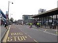
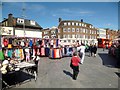
Skyride on Station Parade
The turnout for this year's Skyride was quite poor, as the few cyclists in this view shows.
Image: © Stephen Craven
Taken: 21 Aug 2011
0.04 miles
6
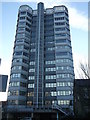
Crown House, Barking
Impressive office block on Linton Road.
Image: © David Anstiss
Taken: 16 Dec 2012
0.05 miles
7
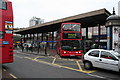
Barking, station exterior
Not only is Barking station very well served by rail, but it is an excellent interchange point for several bus services. The double-decker here is on Route 5 from Canning Town to Romford.
Image: © Dr Neil Clifton
Taken: 28 Nov 2007
0.05 miles
8
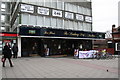
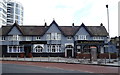
The 'Barking Dog', Barking
Within twenty paces of the station exit is this Wetherspoon's pub, which, as you can see, has provision for those who arrive by bicycle. Offices above the pub. are to let at the time of the photograph. With about the best transport links in East London and a public house underneath, they will soon be taken up.
Image: © Dr Neil Clifton
Taken: 28 Nov 2007
0.05 miles
9
Station Parade, Barking
Station parade and the station building in Barking, East London.
The totem at the left of the image indicates that Barking station is served by two London Underground lines (District and Hammersmith & City) as well as London Overground and national rail services (which are operated by the c2c franchise).
Image: © Malc McDonald
Taken: 21 Oct 2018
0.06 miles
10
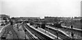
Barking Station
View eastwards showing this major station as it was in 1961. That was not long after the station was comprehensively rebuilt and flyovers and a fly-under had been incorporated to allow ready flow of freight from Ripple Lane Yard and elsewhere down the Tilbury Line to the west and north over the main commuter lines from Fenchurch Street and the District Line. The platforms served (left to right): bay for terminating Kentish Town service, eastbound District (Upminster) Line, bay for terminating Hammersmith & City Line, with beyond a second face for eastbound District Line, Down and Up Southend direct lines, westbound District Line, down Tilbury line with an ex-War Department 2-8-0, and (the other side of the island) up Tilbury Line. The last two served both the Fenchurch Street route and (via a flyove), the route via Woodgrange Park to the rest of the national system. The Fenchurch Street to Tilbury, Southend and Shoeburyness lines were electrified a little over a year later.
Image: © Ben Brooksbank
Taken: 12 May 1961
0.06 miles