Barking Station
Introduction
The photograph on this page of Barking Station by Ben Brooksbank as part of the Geograph project.
The Geograph project started in 2005 with the aim of publishing, organising and preserving representative images for every square kilometre of Great Britain, Ireland and the Isle of Man.

There are currently over 7.5m images from over 14,400 individuals and you can help contribute to the project by visiting https://www.geograph.org.uk
Barking Station
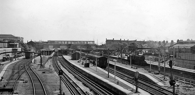
Image: © Ben Brooksbank Taken: 12 May 1961
View eastwards showing this major station as it was in 1961. That was not long after the station was comprehensively rebuilt and flyovers and a fly-under had been incorporated to allow ready flow of freight from Ripple Lane Yard and elsewhere down the Tilbury Line to the west and north over the main commuter lines from Fenchurch Street and the District Line. The platforms served (left to right): bay for terminating Kentish Town service, eastbound District (Upminster) Line, bay for terminating Hammersmith & City Line, with beyond a second face for eastbound District Line, Down and Up Southend direct lines, westbound District Line, down Tilbury line with an ex-War Department 2-8-0, and (the other side of the island) up Tilbury Line. The last two served both the Fenchurch Street route and (via a flyove), the route via Woodgrange Park to the rest of the national system. The Fenchurch Street to Tilbury, Southend and Shoeburyness lines were electrified a little over a year later.
Images are licensed for reuse under creativecommons.org/licenses/by-sa/2.0
Image Location
Latitude
51.539131
Longitude
0.08103