IMAGES TAKEN NEAR TO
New Road, HEBDEN BRIDGE, HX7 5RS
Introduction
This page details the photographs taken nearby to New Road, HX7 5RS by members of the Geograph project.
The Geograph project started in 2005 with the aim of publishing, organising and preserving representative images for every square kilometre of Great Britain, Ireland and the Isle of Man.

There are currently over 7.5m images from over14,400 individuals and you can help contribute to the project by visiting https://www.geograph.org.uk
Image Map
Images are licensed for reuse under creativecommons.org/licenses/by-sa/2.0
Notes
- Clicking on the map will re-center to the selected point.
- The higher the marker number, the further away the image location is from the centre of the postcode.
Image Listing (46 Images Found)
Images are licensed for reuse under creativecommons.org/licenses/by-sa/2.0
Image
Details
Distance
1
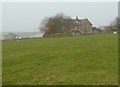
Broad Fold from the footpath from Moorland Cottages to New Road
The house is dated 1784, and according to the listed building details the barn, now converted to domestic use, was added in the 19C.
Image: © Humphrey Bolton
Taken: 23 Mar 2012
0.01 miles
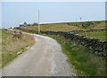
3
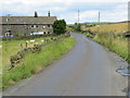
New Road near Slate Delf Farm
Looking north-eastward.
Image: © Peter Wood
Taken: 9 Aug 2017
0.04 miles
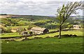
4
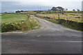
Track to Round Hill Farm
The track shares the route with a bridleway.
Image: © Bill Boaden
Taken: 25 Sep 2011
0.04 miles
5
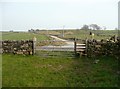
The eastern end of Hebden Royd FP 125
On the far side of New Road the broad track up the hillside is Bridleway 125, leading to Slate Delfs Hill.
Image: © Humphrey Bolton
Taken: 23 Mar 2012
0.04 miles
6
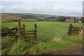
Footpath to Cragg Vale
It descends from Round Hill where it joins the Calderdale Way.
Image: © Bill Boaden
Taken: 25 Sep 2011
0.06 miles
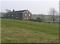
7
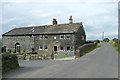
Broad Fold, New Road, Mytholmroyd
Broad Fold is Grade II listed. It is dated 1784, with initials H / R + M. The attached barn, now part of the house, was added in the mid-19C.
Image: © Humphrey Bolton
Taken: 19 Jul 2010
0.06 miles
8
The driveway to Slate Delfs Farm and Round Hill
This is Hebden Royd Bridleway 125. The disused quarry is Warcock Delf (sandstone).
Image: © Humphrey Bolton
Taken: 23 Mar 2012
0.07 miles