IMAGES TAKEN NEAR TO
Burnley Road, HEBDEN BRIDGE, HX7 5PD
Introduction
This page details the photographs taken nearby to Burnley Road, HX7 5PD by members of the Geograph project.
The Geograph project started in 2005 with the aim of publishing, organising and preserving representative images for every square kilometre of Great Britain, Ireland and the Isle of Man.

There are currently over 7.5m images from over14,400 individuals and you can help contribute to the project by visiting https://www.geograph.org.uk
Image Map
Images are licensed for reuse under creativecommons.org/licenses/by-sa/2.0
Notes
- Clicking on the map will re-center to the selected point.
- The higher the marker number, the further away the image location is from the centre of the postcode.
Image Listing (83 Images Found)
Images are licensed for reuse under creativecommons.org/licenses/by-sa/2.0
Image
Details
Distance
1
Former telephone exchange, Burnley Road
Built in 1940, during the Second World War.
Image: © Humphrey Bolton
Taken: 2 Jul 2012
0.03 miles
2
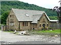
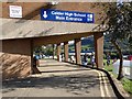
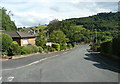
Brier Hey Lane, Mytholmroyd
This was a narrow lane from Brier Hey on the main road to a farm and house in grounds called Upper White Lee. The lane was effectively the driveway to the house, but was also a public footpath to Midgley Road (Hebden Royd FP41). The building on the left is the Calder High School Sixth Form and Community Learning Centre.
Image: © Humphrey Bolton
Taken: 8 Sep 2011
0.03 miles
3
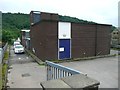
Telephone exchange, Burnley Road
A large building, with flat roofs typical of the 1960s. It was built next to the previous telephone exchange (see Image).
Image: © Humphrey Bolton
Taken: 2 Jul 2012
0.03 miles
4
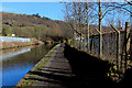
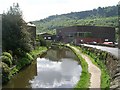
Rochdale Canal outside Business Park, Eastern Mytholmroyd
Image: © Chris Heaton
Taken: 22 Feb 2019
0.11 miles
5
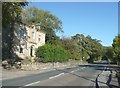
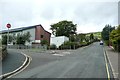
House, Burnley Road A646, Mytholmroyd
Too grand for a lodge, yet this house is at the end of a driveway to Ewood Hall and was called Ewood gate on the 1907 1:2500 map.
Image: © Humphrey Bolton
Taken: 16 Oct 2008
0.11 miles
6
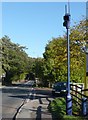
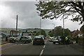
Traffic monitoring sensor, Burnley Road A646, Mytholmroyd
This, at the start of the 30mph zone through Mytholmroyd is part of the Trafficmaster system which monitors traffic congestion.
Image: © Humphrey Bolton
Taken: 16 Oct 2008
0.11 miles
10
Road traffic accident on Burnley Road, Mytholmroyd (A646)
Around twenty five minutes earlier the Renault Laguna on the left collided with the Volkswagen Golf on the right. Police were in attendance. An 89 year old man was later taken to hospital.
Image: © Phil Champion
Taken: 17 May 2011
0.14 miles