IMAGES TAKEN NEAR TO
Bethel Terrace, SOWERBY BRIDGE, HX6 3QX
Introduction
This page details the photographs taken nearby to Bethel Terrace, HX6 3QX by members of the Geograph project.
The Geograph project started in 2005 with the aim of publishing, organising and preserving representative images for every square kilometre of Great Britain, Ireland and the Isle of Man.

There are currently over 7.5m images from over14,400 individuals and you can help contribute to the project by visiting https://www.geograph.org.uk
Image Map
Images are licensed for reuse under creativecommons.org/licenses/by-sa/2.0
Notes
- Clicking on the map will re-center to the selected point.
- The higher the marker number, the further away the image location is from the centre of the postcode.
Image Listing (56 Images Found)
Images are licensed for reuse under creativecommons.org/licenses/by-sa/2.0
Image
Details
Distance
1
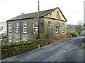
Bethel Baptist Chapel
No longer a chapel, and converted to a house. It was opened in 1865, and closed in 1958 due to dry rot. The last service was held on 29th December 1958. (Information from Malcolm Bull's Calderdale Companion)
Image: © Humphrey Bolton
Taken: 23 Mar 2015
0.02 miles
2
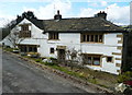
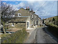
Lower Spark House Farmhouse
This building is listed, Grade II. It is dated 1677 with initials IT.
Image: © Humphrey Bolton
Taken: 23 Mar 2015
0.07 miles
3
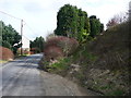
Parkfield Lane at London Road
Although rough and unsurfaced, Parkfield Lane is an adopted highway. It is signposted as a bridleway.
Image: © Humphrey Bolton
Taken: 23 Mar 2015
0.12 miles
4

Roadside stones, Fall Lane
Stones like these are often seen against stone walls alongside steep roads. They were perhaps to stop runaway vehicles, and avoid damage to the wall.
Image: © Humphrey Bolton
Taken: 23 Mar 2015
0.12 miles
6
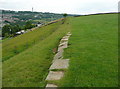
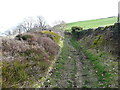
Flagstones on an alternative route for Sowerby Bridge FP77, Norland
This route along the bottom edge of the field is not shown on OS maps, but is the footpath according to the farmer's signs and is paved with old flagstones.
Image: © Humphrey Bolton
Taken: 15 Jun 2015
0.14 miles
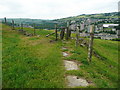
7
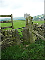
Stile and gate on Sowerby Bridge FP77, Norland
The map shows the path turning left, but the farmer's sign points to the right. This latter route goes down alongside the wall and meets a flagged path along the bottom side of the field, see Image
Image: © Humphrey Bolton
Taken: 15 Jun 2015
0.14 miles
10
Gate and stile on Sowerby bridge FP77, Norland
Image: © Humphrey Bolton
Taken: 15 Jun 2015
0.16 miles