IMAGES TAKEN NEAR TO
Greetland, HALIFAX, HX4 8NR
Introduction
This page details the photographs taken nearby to HX4 8NR by members of the Geograph project.
The Geograph project started in 2005 with the aim of publishing, organising and preserving representative images for every square kilometre of Great Britain, Ireland and the Isle of Man.

There are currently over 7.5m images from over14,400 individuals and you can help contribute to the project by visiting https://www.geograph.org.uk
Image Map
Images are licensed for reuse under creativecommons.org/licenses/by-sa/2.0
Notes
- Clicking on the map will re-center to the selected point.
- The higher the marker number, the further away the image location is from the centre of the postcode.
Image Listing (71 Images Found)
Images are licensed for reuse under creativecommons.org/licenses/by-sa/2.0
Image
Details
Distance
1
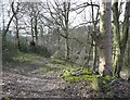
Track to Upper Gatehead Mill, Stainland
Or rather the site of it, as it was demolished over 110 years ago. It was a wire works in 1850.
Image: © Humphrey Bolton
Taken: 9 Mar 2008
0.03 miles
2
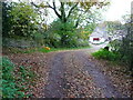
Stubbing Lane approaching Stubbing, Stailnland
This is on Elland Bridleway 60. Footpath 60 goes to the left.
Image: © Humphrey Bolton
Taken: 31 Oct 2015
0.05 miles
3
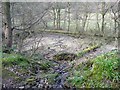
Millpond for Gatehead Mill, Stainland
Many millponds have been maintained for fishing, but this one has been drained. A fallen tree lies across it. A stone retaining wall behind the trees on the left marks the site of Upper Gatehead Mill.
Image: © Humphrey Bolton
Taken: 9 Mar 2008
0.08 miles
4
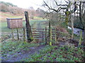
Stile at the parish boundary
This is where you pass from Barkisland into Greetland. The footpath changes from Ripponden FP75 to Elland FP37. The stile is a chicane around a metal gate.
Image: © Humphrey Bolton
Taken: 8 Jan 2015
0.08 miles
5

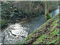
A step in the Black Brook
The water is flowing over a step of presumably relatively hard rock, which is exposed to the left of the water. The rock looks black, which is perhaps why the stream has its name.
Image: © Humphrey Bolton
Taken: 8 Jan 2015
0.08 miles
6
Black Brook at the overflow from the Gate Head Mill millpond
Image: © Humphrey Bolton
Taken: 8 Jan 2015
0.08 miles
7
Black Brook at the overflow from the Gate Head Mill dam
Image: © Humphrey Bolton
Taken: 8 Jan 2015
0.08 miles
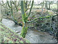
8
Elland FP37 alongside the Black Brook
This path is shown on the 1850 six-inch map. The stone retaining wall on the other side of the stream is the remains of Upper Gate Head Mill.
Image: © Humphrey Bolton
Taken: 8 Jan 2015
0.10 miles
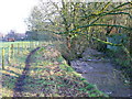
9
Ripponden FP75 at the junction with the branch to Branch Road
This riverside path is shown on the 1850 six-inch map.
Image: © Humphrey Bolton
Taken: 8 Jan 2015
0.10 miles
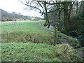
10
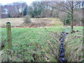
A branch of Ripponden FP75 alongside a field boundary ditch
The ditch was probably dug as part of a drainage system for the adjoining fields. The path follows it up to Zechariah Wood, and is first shown on the 1893 1:2500 map.
Image: © Humphrey Bolton
Taken: 8 Jan 2015
0.10 miles