IMAGES TAKEN NEAR TO
Upper Hall Fold, HALIFAX, HX4 0HL
Introduction
This page details the photographs taken nearby to Upper Hall Fold, HX4 0HL by members of the Geograph project.
The Geograph project started in 2005 with the aim of publishing, organising and preserving representative images for every square kilometre of Great Britain, Ireland and the Isle of Man.

There are currently over 7.5m images from over14,400 individuals and you can help contribute to the project by visiting https://www.geograph.org.uk
Image Map
Images are licensed for reuse under creativecommons.org/licenses/by-sa/2.0
Notes
- Clicking on the map will re-center to the selected point.
- The higher the marker number, the further away the image location is from the centre of the postcode.
Image Listing (59 Images Found)
Images are licensed for reuse under creativecommons.org/licenses/by-sa/2.0
Image
Details
Distance
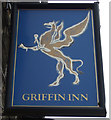
4
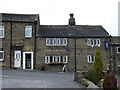
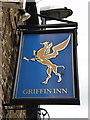
The Griffin Inn, Barkisland
On Stainland Road.
Image: © JThomas
Taken: 14 Mar 2015
0.05 miles
6
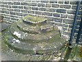
Old Wayside Cross by Stainland Road, Barkisland, Ripponden
Barkisland Cross, old base, by the UC road, in parish of Ripponden (Calderdale District), Stainland Road, by Nos. 19 & 21, Barkisland, as steps to form a mounting block.
Grade II listed.
List Entry Number: 1232698 https://historicengland.org.uk/listing/the-list/list-entry/1232698
Surveyed
Milestone Society National ID: YWCA_RIP01
Image: © Milestone Society
Taken: Unknown
0.07 miles
7
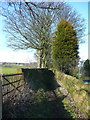
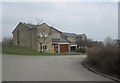
Stony Croft Lane, Barkisland
The field gates along this track are distinctive. They are made from strips of metal.
Image: © Humphrey Bolton
Taken: 14 Mar 2016
0.08 miles
8
Stony Croft Lane at Stainland Road
Stony Croft Lane seems to be a field access track as it does not lead to a farm of that name. It ends after crossing Sandyfoot Clough, although maps from 1850 up to 1963 or later show a track over a field to Wood Royd.
Image: © Humphrey Bolton
Taken: 14 Mar 2016
0.08 miles
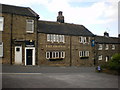
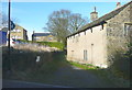
10

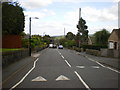
Stainland Road, Barkisland
This, the main street of Barkisland, slopes steeply down into the valley with short rows of terrace houses near the top and larger houses culminating in Barkisland Hall at the bottom end.
Image: © Humphrey Bolton
Taken: 11 Nov 2004
0.09 miles