IMAGES TAKEN NEAR TO
Sandy Fore, HALIFAX, HX2 7TD
Introduction
This page details the photographs taken nearby to Sandy Fore, HX2 7TD by members of the Geograph project.
The Geograph project started in 2005 with the aim of publishing, organising and preserving representative images for every square kilometre of Great Britain, Ireland and the Isle of Man.

There are currently over 7.5m images from over14,400 individuals and you can help contribute to the project by visiting https://www.geograph.org.uk
Image Map
Images are licensed for reuse under creativecommons.org/licenses/by-sa/2.0
Notes
- Clicking on the map will re-center to the selected point.
- The higher the marker number, the further away the image location is from the centre of the postcode.
Image Listing (45 Images Found)
Images are licensed for reuse under creativecommons.org/licenses/by-sa/2.0
Image
Details
Distance
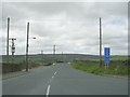
1
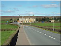
Mount Tabor Road, near Wainstalls
A view along Mount Tabor Road, as it enters the small village of Wainstalls in the hills west of Halifax.
Image: © Malc McDonald
Taken: 29 Aug 2016
0.04 miles
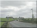
2
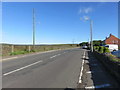
Mount Tabor Road
The view south from the Crossroads Inn
Image: © Richard Rogerson
Taken: 8 Jul 2017
0.05 miles
3
Bridleway off Mount Tabor Road, Warley
This lane does not have a name, but goes past Upper Reap Hurst.
Image: © Humphrey Bolton
Taken: 26 Mar 2009
0.09 miles
4
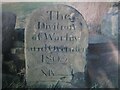
Old Boundary Marker on Balkram Edge near Mixenden
Township Boundary Marker against a drystone wall and beside the start of a bridleway on the north side of Balkram Edge, near Mixenden, Halifax. On the former boundary of Warley and Ovenden townships in Halifax parish. Both became parishes in 1866 but by 1900 had been absorbed into Halifax parish. See also https://www.geograph.org.uk/photo/1221038.
Milestone Society National ID: YW_HALI08pb
Image: © T Wall
Taken: 1 Aug 2023
0.09 miles
5
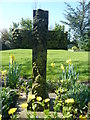
Mount Pleasant Wainstalls
Headstone commemorating the death of Wainstalls Mill children - carved by Wilfred Holgate
Image: © Ron Holgate
Taken: 19 Apr 2009
0.09 miles
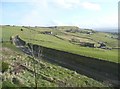
6
Mount Tabor Road - viewed from Balkram Edge
Image: © Betty Longbottom
Taken: 30 Aug 2010
0.11 miles
7
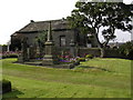
Mount Pleasant Chapel Wainstalls
Mount Pleasant built through public subscription in 1857 - viewed across the burial ground.
Image: © Ron Holgate
Taken: 16 Aug 2003
0.11 miles
8
Wainstalls Lane - viewed from Mount Tabor Road
Image: © Betty Longbottom
Taken: 30 Aug 2010
0.11 miles
9
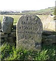
Boundary stone, Balkram Edge
A stone of superior quality, dated 1805 and with the mysterious number 14 in Roman numerals. There are many boundary stones shown on the 1850 six-inch map along this boundary, so perhaps they are all numbered in sequence. I shall investigate.
Image: © Humphrey Bolton
Taken: 20 Mar 2009
0.11 miles
10
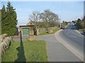
Balkram Edge, Ovenden
That is the name of the road. This image shows the position of the old boundary stone (between Warley and Ovenden), at the corner of the wall on the left. The triangular part of the shadow is a public footpath sign. The bulges in front of it are the shadow of photographer desperately trying to merge it into that of the telephone pole.
Image: © Humphrey Bolton
Taken: 20 Mar 2009
0.11 miles