IMAGES TAKEN NEAR TO
Morley Hall Terrace, HALIFAX, HX2 6HA
Introduction
This page details the photographs taken nearby to Morley Hall Terrace, HX2 6HA by members of the Geograph project.
The Geograph project started in 2005 with the aim of publishing, organising and preserving representative images for every square kilometre of Great Britain, Ireland and the Isle of Man.

There are currently over 7.5m images from over14,400 individuals and you can help contribute to the project by visiting https://www.geograph.org.uk
Image Map
Images are licensed for reuse under creativecommons.org/licenses/by-sa/2.0
Notes
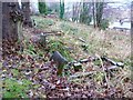
- Clicking on the map will re-center to the selected point.
- The higher the marker number, the further away the image location is from the centre of the postcode.
Image Listing (84 Images Found)
Images are licensed for reuse under creativecommons.org/licenses/by-sa/2.0
Image
Details
Distance
1
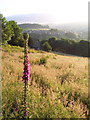
Foxglove and meadow, Luddendenfoot
Looking N at Luddendenfoot from Sowerby Lane. The Kershaw estate can be seen on the next hill. While the Ordnance Survey spelling is "Luddenden Foot", roadsigns follow local custom with "Luddendenfoot".
Image: © Mark Anderson
Taken: 27 Jun 2005
0.03 miles
2
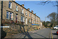
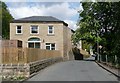
Morley Hall Terrace
Looking along Morley Hall Lane. The estate agent's board is for number 5 which is on the market with an asking price of £185,000.
Image: © Mark Anderson
Taken: 2 Apr 2007
0.03 miles
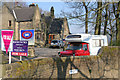
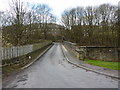
3
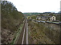
Looking north west from Spring View Road bridge
The terraced houses on the right are Boys Scarr
Image: © Alexander P Kapp
Taken: 7 Apr 2010
0.10 miles
4
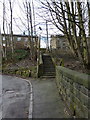
Steps, between Bank View and Spring View Road
Image: © Alexander P Kapp
Taken: 7 Apr 2010
0.10 miles
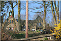
5
Refurbished house, Luddenden Foot
Behind it are some new houses, and then Milner Lodge.
Image: © Humphrey Bolton
Taken: 13 May 2010
0.11 miles
6
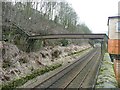
Pipe bridge over the railway, Luddenden Foot
This is bridge no. MVN2/144. It carries two pipes of different sizes. In the distance is the next bridge carrying a steep road.
Image: © Humphrey Bolton
Taken: 27 Feb 2009
0.11 miles
7
Roofline of former school, Morley Hall Lane
Looking up from Blackwood Hall Lane.
Image: © Mark Anderson
Taken: 2 Apr 2007
0.11 miles
8
Former School, Morley Hall Lane
Now converted to private housing, this was once the Luddendenfoot Church of England school. Blackwood Hall Lane leads steeply down to the right.
Image: © Mark Anderson
Taken: 2 Apr 2007
0.11 miles
9
Lower part of the graveyard of the former St Mary?s Church, Luddendenfoot
See also Image This part is not cared for at present, although some graves are evidently visited.
Image: © Humphrey Bolton
Taken: 26 Nov 2012
0.11 miles
10
Spring View Road, bridge
With Bank View in the trees
Image: © Alexander P Kapp
Taken: 7 Apr 2010
0.12 miles